BEST PARAGLIDING SITES IN UNITED STATES
There is 801 sites to discover in United States and 4 guides available
Available guides:
Salt Lake City
| Probability of Paragliding in the next days |
| 3 days |
7 days |
16 days |
| 41% |
45% |
47% |
Salt Lake City, particularly the Point of the Mountain, is renowned for its exceptional paragliding conditions, making it a prime destination for enthusiasts of the sport. Here's a detailed overvie ...
View guide
Soboba
| Probability of Paragliding in the next days |
| 3 days |
7 days |
16 days |
| 78% |
73% |
65% |
...
View guide
San-Francisco
| Probability of Paragliding in the next days |
| 3 days |
7 days |
16 days |
| 67% |
53% |
48% |
Why go to this place
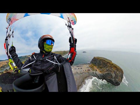
San Francisco and Mussel Rock (also known as "The Dump") offer unique paragliding experiences with stunning views. Flying over Mussel Rock provides a breathtaking persp ...
View guide
Aspen
| Probability of Paragliding in the next days |
| 3 days |
7 days |
16 days |
| 67% |
67% |
61% |
Why go to Aspen, Colorado
Aspen, nestled in the heart of the Rocky Mountains, is a prime destination for paragliding enthusiasts seeking adventure amidst some of the most stunning landscape ...
View guide
The Top 20 Paragliding sites in United States:
Monterey_Sand City, CA
/-121.843536346345,36.6254548940127,13/600x300@2x?access_token=pk.eyJ1Ijoic2Vic3dhbiIsImEiOiJjbGZsZ3E1MWowMXRtM3JucGZsbmVsNWlxIn0.NRc39EhAm1tQjmYNgV4zaQ)
Sand City/Marina is a seven-mile coastal ridge located off Highway 1, north of Monterey, California. The site benefits from a consistent onshore flow as the Monterey Bay funnels wind into the Salinas Valley. When the wind is “straight-in,” it ranges between 270° and 290°. This is a USHPA insured site under an agreement with Marina State Beach.
Understanding ridge soaring and ridge rules is essential. You should have your speed system engaged and be prepared to use it if necessary. The ridge is relatively low, so the wind must be fairly strong (~12-15 MPH for paragliders) to generate soarable lift. Excellent ground handling skills and high wind launching and landing skills are required to safely fly this site. However, with consistent wind and soft sand, Sand City can be a good place for novice pilots to work on ground handling skills, if you don't mind getting sand in your wing. Ask the locals for the best place to practice.
You are required to sign in at the Marina when you fly either Marina or Lake Court. A site intro from a local pilot before launching is recommended. They can advise you on how to stay up, cross the gaps, and avoid trouble spots. They can also tell you if the wind is sufficient or excessive.
**Launches:**
**Marina State Beach (Reservation Road):** This is a very flat, nearly sea-level dune launch, primarily used by hang glider pilots. All pilots must sign in to launch and land at this site. The sign-in sheet is located at the kiosk/signboard near the wind sock. If you launch from Lake Court, you still need to sign in here first. If you're flying at Sand City, you don't need to sign in unless you plan to fly north and land at Lake Court. The kiosk has other info, including a map of how to get to Lake Court. You must be a rated USHGA member, and if you are a P3/H3, you are required to have a local instructor give you a site intro and sign you off before you fly here. You are also required to carry a sheath knife on your harness in the event of a water landing, although a hook knife is currently considered acceptable for paraglider pilots.
**Lake Court:** This is a higher (~150’ MSL), walk-up launch about a mile south of Marina State Beach and is a regulated USHGA site. USHGA membership and signing in at Marina State Beach are required for flying here. Go inland on Reservation Road, turn right on Lake Drive, and make an immediate left jog. Follow Lake Drive to the end, where it becomes Lake Court. Park by the fence and walk up the dune path. The launch is the highest smooth area on the top and to the right. Lake Court can offer good soaring on a light, south day, but it can also be dangerous if the wind is too strong.
**Sand City:** The most popular paragliding launch is five or six miles south of Lake Court, at Sand City. This site is unregulated, but you should sign in at Marina State Beach if you think you may fly north and land there.
**Primary Hazards:**
**Water Landings:** There is usually plenty of beach below the entire ridge, but sinking out is common, so stay clear of the water as you land. Water landings can be lethal. Always carry a hook knife on your harness and be prepared to cut yourself out immediately if you are being pulled into the water. Forget about saving your equipment.
**Blow Backs:** On high-wind days, stay low and out front, ready to apply your speed bar, to avoid being blown back over the ridge. You should land immediately if you are having trouble penetrating.
**Scratching:** On light to moderate days, pilots are often tempted to fly close to the terrain. This is a hazardous practice in any conditions.
**Getting Dragged:** Always wear a helmet when you’re hooked in and make sure that you can quickly disable your wing in high winds.
**Debris:** There is a variety of natural and man-made debris on the beach and launches, and the dunes are covered with ice plant. Although this is usually only a nuisance, it can damage your wing. Be especially careful not to launch with twigs or other debris in your lines.
**Snowy Plover Habitat:**
The Snowy Plover is a tiny shorebird that nests and forages for food on sandy beaches. Unfortunately, people and pets can step on their nests, interrupt their foraging, and threaten their fledglings. The plover has been on the National Audubon Society's Blue List of declining species since 1972, and in 1997, it was listed as a U.S. Endangered Species. California State Parks has erected metal fences to protect their nesting area during the spring and summer months. These fences are very hard to see from the air. Do not walk, launch, or land anywhere inside the fenced area. If you accidentally find yourself in the fenced area, get out as soon as possible.
Be especially careful at high tide. Because the fenced area is so extensive, your landing options are significantly restricted at high tide. Make sure you have safe and legal landing options at all times. The most prudent flight plan would be to launch from Sand City during plover season. Avoid the north end of the ridge unless you're certain that you won't sink out.
**Directions and Access:**
From Highway 1 South, the exit for Marina State Beach is Reservation Road. The exit for Sand City, approximately six miles south of Marina, is Fremont Boulevard. Take the Fremont Boulevard exit and go under the freeway. Park on the street or in the nearby shopping center. Walk back under the freeway and follow the railroad tracks north briefly, then head toward the ocean. The primary launch is at the north end of the flat area, about 100 yards north of the big dune. You can also launch off the dune, but it's often harder to get onto the main ridge from there.
The launch is located here because it's private property with access, but it's not the best spot to launch on the ridge. The ridge is very low at this launch (~50’ MSL), and there's a gap to the north of the launch that can be difficult to cross. If you sink out, you can use the 're-launch bowl' on the other side of the gap. You can't miss the bowl—the sand at the bottom is carved into sculptures.
For more information, check out these links:
- [Wilder Adventures](https://www.wilderadventures.com/launch/905/sand-city)
- [Fly Zephyr](http://www.flyzephyr.com/sand-city.html)
- [Coastal Condors](https://www.coastalcondors.org/)
- [Paragliding Lessons](https://www.paragliding-lessons.com/sand-city-flying-site/)
- [BHGC](http://www.bhgc.org/sites/#site_sand-city-monterey-bay-ca)
Flying at Marina requires a current H3 or P3 USHPA rating or higher.
View spot
Mussel Rock
/-122.494310438633,37.6719629149719,13/600x300@2x?access_token=pk.eyJ1Ijoic2Vic3dhbiIsImEiOiJjbGZsZ3E1MWowMXRtM3JucGZsbmVsNWlxIn0.NRc39EhAm1tQjmYNgV4zaQ)
Mussel Rock is located about 20 minutes SW of San Francisco, near the border of between Pacifica and Daly City. Below are directions from San Francisco.
There are 7 launch, more informations below:
https://www.bayareaparagliding.com/mussel-rock-paragliding-site/Mussel Rock is an amazing flying site located in Daly City/Pacifica, USA. Behind the launches, the cliffs rise as high as 640 feet MSL. The soarable cliffs extend to the north and south for a couple of miles in each direction. On a good day, the winds are smooth, and you can enjoy breathtaking views of San Francisco and the greater Bay Area. One of the greatest features of this site is the abundant landing area that is virtually rotor-free. This is because the plateau area near the launches lies behind a ridge that has a smooth edge without a sharp drop-off. However, the nature of the site is quite complex. The hazards vary based on the wind direction and velocity, as well as the rapid changes that can occur with the weather. On one day, the wind can be perfectly steady at 10 MPH at the low cliffs and not much more than 13 MPH up high with virtually no gust factor. On another day, the wind might be 10 MPH and W at the lower launches but blowing 20 MPH in another direction and extremely gusty at the upper cliffs. Clear, blue days are rare during the summer. On some days, the fog can be all the way down to the beach, blocking flying completely. On others, the fog can be up above cliff level, with frequent level changes. Continuous monitoring of the fog and winds should become second nature as you fly here. Landing in the water is not an option. There have been two drowning deaths of paraglider pilots at Mussel Rock. It is imperative to know where the tide is each day you fly. You can visually check the tides and how much beach is there from several vantage points between the parking lot and Walker Launch. Prior to heading to Mussel Rock to fly, you can look at this tide chart that is set for Pacifica’s beaches. For planning and checking on conditions, there is a useful page that I created about wind and weather conditions for the Mussel Rock area with the local weather stations. Different wind directions and velocities change how safety should be approached at the different launches and LZs. Vertical and horizontal edges act as triggers and create many hazardous rotors on the face of the Westlake cliffs and at the other connected ridges. Mussel Rock is often a busy site. On some days, paragliding pilots share the air with hang gliders as well as RC planes. In addition to the site being unregulated, not every pilot perceives the right-of-way rules the same. Being comfortable with such traffic and the standard rules is critical, but also being able to adapt to a breach of rules becomes necessary. All pilots should continuously fly in a predictable fashion and keep their eyes and attention proactive for other pilots and crafts. When you begin flying any new site, get in touch with the locals and gather information. This is even more important with Mussel Rock because of the complex nature of the site. This article, though it attempts to cover much, cannot come close to covering all of the hazards. Every day is different at a site like this, so understanding the effect of different wind directions, changing conditions, fog, and other variables takes time and firsthand observations. If Mussel Rock were regulated, it would likely be a P3 site with a P2 sign-off after an introductory period. When compared to other ridge soaring sites, Mussel Rock has unique factors that make it much more hazardous than others. The local club, the Bay Area Paragliding Association (BAPA), looks after the site to promote site safety. Never fly alone. Without another person’s awareness of anything happening to you during a flight, help will not be available. The other person does not necessarily have to be a pilot. Someone just needs to be there and be aware of your presence. Awareness of risks and risk management are the keys to flying here. This site guide will cover the prominent issues related to the site but cannot cover all of them. More important than reading this information is to get a thorough introduction to the site from a local pilot or instructor. After this, find some local pilots to join and help you grow your understanding of the site dynamics. There have been several fatalities at the site and many serious injuries. The major risks of flying here include: Water Landing and Possibility of Drowning: Sometimes the tides cover the entire beach. Other times the surf and water cover most of the beach. There are days where landing on the beach is possible, but landing at the bailout LZs above the surf zone is a much safer method. Every time you fly at Mussel Rock, prior to flying, check the beach and gain a perspective of how high the tide is. If you ever do land on the beach, immediately disconnect from the wing and then move the glider as far as possible from the water. If a wing is in the water, remember that it is only equipment and your primary responsibility is ensuring your safety from the water. Blowbacks: Mussel Rock has high cliffs above lower launches. The wind gradient can create huge differences in wind velocity between launch and flights to upper cliffs. Above and behind the high cliffs are houses, roads, and power lines. When the wind is strong, the mechanical turbulence in this area is extreme. Many pilots have become victims to the high winds above the top of the ridge and have been blown back. Prevention methods are far less complex than those required once a blowback begins. Read this article to learn methods for continual wind speed monitoring while flying at Mussel Rock. Rotors: Mechanical turbulence can be caused by various factors, and understanding where it is likely to occur is crucial. Class B Airspace: The departure path for San Francisco International Airport flies directly over Mussel Rock. The ceiling for ultralight craft is 1,600 ft. (changed in 2019, was 1,500 previously). Normally it is difficult to fly this high, but in a wind shear, pilots can exceed this altitude. Being in the path of a commercial jet would not only endanger you but the jet and everyone in it. If you are flying and have the skill to fly in a wind shear, find a way to stay below 1,500 ft at Mussel Rock. North of the Westlake cliffs, the ceiling lifts to 2,100 ft.
Marina
Sand City is an enjoyable site worth exploring, particularly if you're looking for a fun place to soar and improve your kiting skills. While experienced pilots may find the flying limited, the site is perfect for anyone who wants to enjoy a peaceful flight.
Landing at Sand City can be a tricky affair due to strict state park regulations. Most of the ridge is off-limits for top landing, except for regulated launch areas in the north which require P3 pilot certification and membership with the local club. Alternatively, you may choose to top land at the unregulated area. However, landing on other parts of the ridge may result in a ticket from the park rangers and may also harm the ice plant and plover nesting areas. You may land on the beach as long as you maintain a safe distance from the water. But, keep in mind that your options for relaunching may be limited if you land too far away from designated areas, and you may have to hike or kite through the sand.
View spot
Mussel Rock_Dumps_Walker's
/-122.493697715483,37.6726548450636,13/600x300@2x?access_token=pk.eyJ1Ijoic2Vic3dhbiIsImEiOiJjbGZsZ3E1MWowMXRtM3JucGZsbmVsNWlxIn0.NRc39EhAm1tQjmYNgV4zaQ)
Mussel Rock, located in Daly City/Pacifica, USA, is a frequently used paragliding site known for its soaring opportunities and some cross-country (XC) potential. This site is exclusively for paragliding, and the emergency frequency is 147.495 MHz (as of June 2020). Mussel Rock is one of the most popular flying sites in the Bay Area due to its easy access. However, it is also one of the most complex. While you can enjoy long, relaxing flights with sea breezes and beautiful ocean vistas, you must be cautious about changing wind strength and direction, rotors, high tides, and traffic from other paragliders, hang gliders, radio-controlled planes, and general aviation. Blowbacks are a common occurrence at Mussel Rock, often leading to serious accidents, including fatalities due to electrocution, drowning, and crashes. The site is unregulated, making it a frequent choice for inexperienced and visiting pilots. Paragliding at Mussel Rock is not officially sanctioned but is currently allowed. The future of this site depends on its safety record. It is strongly recommended to get a site introduction before flying at Mussel Rock. Experienced pilots are usually present on soarable days and can provide valuable insights. For wind direction, velocity, and temperature at nearby Fort Funston, call 415.333.0100 or 415.584.9891. In case of emergencies, the local '911' number is 650.355.4151. For more detailed information, you can visit: - [Wilder Adventures](https://www.wilderadventures.com/launch/839/mussel-rock-daly-city) - [Fly Zephyr](http://www.flyzephyr.com/the-dump.html) - [Air Time Mussel Rock Site Guide](https://www.paragliding-lessons.com/mussel-rock-flying-site/) - [Avoiding Blowbacks at The Dump](https://www.paragliding-lessons.com/avoiding-blowbacks-at-mussel-rock/) - [Pacifica and Daly City Wind Conditions](https://www.paragliding-lessons.com/pacifica-and-daly-city-wind-conditions/) - [Bay Area Hang Gliding Club](http://www.bhgc.org/sites/#site_the-dumps-mussel-rock-ca) - [Weather Forecast](https://forecast.weather.gov/MapClick.php?lat=37.672164&lon=-122.493943&site=rev&unit=0&lg=en&FcstType=text#.Y1mWnz1Bypo) - [Mussel Rock Site Guide](https://www.paragliding-lessons.com/mrsg/) The cliffs behind the launches rise as high as 640′ MSL, with soarable cliffs extending north and south for a couple of miles. On good days, the winds are smooth, offering views of San Francisco and the greater Bay Area. The landing area is abundant and virtually rotor-free due to the plateau area near the launches lying behind a ridge with a smooth edge. However, the site is complex, with hazards varying based on wind direction and velocity, as well as rapid weather changes. Continuous monitoring of fog and winds is essential. Landing in the water is not an option, and there have been drowning incidents. Always check the tide levels before flying. Mussel Rock is often busy, with paragliders sharing the air with hang gliders and RC planes. Understanding and adapting to traffic and right-of-way rules is crucial. Always fly predictably and stay aware of other pilots and crafts. For new pilots, getting in touch with locals and gathering information is vital due to the site's complexity. The Bay Area Paragliding Association (BAPA) promotes site safety. Never fly alone; having someone aware of your presence is essential for safety. Primary hazards include water landings, blowbacks, rotors, and Class B airspace restrictions. The ceiling for ultralight craft is 1,600 ft, and exceeding this altitude can be dangerous due to the proximity to San Francisco International Airport's departure path. For more detailed safety information and site dynamics, refer to the provided links and seek guidance from local pilots or instructors.
View spot
Mussel Rock_Coyote
The paragliding site in Daly City / Pacifica, USA, is occasionally used and primarily suitable for experienced pilots due to the need for good lift. The takeoff height is 57 meters, and the site is known for soaring flights. However, it is important to note that there is no escape route to the beach below, which adds to the challenge and requires advanced piloting skills. The site record for distance is 8.2 km.
View spot
Winchester Bowl, CA
/-117.065052488387,33.7298723017169,13/600x300@2x?access_token=pk.eyJ1Ijoic2Vic3dhbiIsImEiOiJjbGZsZ3E1MWowMXRtM3JucGZsbmVsNWlxIn0.NRc39EhAm1tQjmYNgV4zaQ)
Located in California, USA, this paragliding site offers an elevation of 530-580 meters with a height difference of 50 meters. It is regularly used for soaring and some thermalling, making it a decent spot for intermediate pilots. The site features multiple takeoff options, including launches facing West, East, and North.
There are two main launches: one at the top, which is a small southwest-facing launch, and another about 30-40 meters down, which is more south-facing and slightly larger. It takes approximately 20 minutes to walk from the base to the top.
Weather conditions can be quite strong in the middle of the afternoon, typical of Southern California. Be cautious of the airport to the east of the ridge to avoid flying too high.
Winchester Bowl is often used as a backup site when Soboba's conditions are too weak for soaring. However, space is limited, and more than 4-5 pilots in the air can feel crowded unless it's a particularly lifty day.
Pilots have noted that the wind at this site tends to be stronger than forecasted. For example, a forecasted 8-10 mph west wind turned out to be a sustained 12-15 mph from the south. The lower launch is recommended for south winds due to its lighter and more consistent conditions.
For visual insights, you can check out these videos:
- [Video 1](https://player.vimeo.com/video/4922600)
- [Video 2](https://vimeo.com/42946665)
For more detailed information, you can visit [ParaglidingEarth](https://paraglidingearth.com).
View spot
Mussel Rock_Tomcat
/-122.494742677376,37.6679814070424,13/600x300@2x?access_token=pk.eyJ1Ijoic2Vic3dhbiIsImEiOiJjbGZsZ3E1MWowMXRtM3JucGZsbmVsNWlxIn0.NRc39EhAm1tQjmYNgV4zaQ)
Mussel Rock is an amazing flying site. Behind the launches, the cliffs rise as high as 640′ MSL. The soarable cliffs extend to the north and south for a couple of miles in each direction. On a good day, the winds are smooth, and views of San Francisco and the greater Bay Area can be achieved. One of the greatest features of this site is the abundant landing area that is virtually rotor-free. This is because the plateau area near the launches lies behind a ridge that has a smooth edge without a sharp drop-off. At the same time, the nature of the site is quite complex. The hazards vary based on the wind direction and velocity as well as the rapid changes that can occur with the weather. On one day, the wind can be perfectly steady and 10 MPH at the low cliffs and not much more than 13 MPH up high with virtually no gust factor. On another day, the wind might be 10 MPH and W at the lower launches, but be blowing 20 MPH, some other direction, and extremely gusty at the upper cliffs. Clear, blue days are rare during the summer. On some days, the fog can be all the way down to the beach, blocking flying completely. On others, the fog can be up above cliff level, with frequent level changes. Continuous monitoring of the fog and winds should become second nature as you fly here. Landing in the water is not an option! There have been two drowning deaths of Paraglider Pilots at Mussel Rock. It is imperative to know where the tide is each day you fly. You can visually check the tides and how much beach is there from several vantage points between the parking lot and Walker Launch. Prior to heading to Mussel Rock to fly, you can look at this tide chart that is set for Pacifica’s beaches. Below is a full section on avoiding landing in the water and where the bailouts are. For planning and checking on conditions, there is a useful page that I created about wind and weather conditions for the Mussel Rock area with the local weather stations. Different wind directions and velocities change how safety should be approached at the different launches and LZs. Vertical and horizontal edges act as triggers and create many hazardous rotors on the face of the Westlake cliffs and at the other connected ridges. Mussel Rock is often a busy site. On some days, paragliding pilots share the air with hang gliders as well as RC planes. In addition to the site being unregulated, not every pilot perceives the right-of-way rules the same. Being comfortable with such traffic and the standard rules is critical, but also being able to adapt to a breach of rules becomes necessary. All pilots should continuously fly in a predictable fashion and keep their eyes and attention proactive for other pilots and crafts. When you begin flying any new site, get in touch with the locals and gather information. This is even more important with Mussel Rock, because of the complex nature of the site. This article, though it attempts to cover much, cannot come close to covering all of the hazards. Every day is different at a site like this, so understanding the effect of different wind directions, changing conditions, fog, and other variables takes time and first-hand observations. If Mussel Rock were regulated, it would likely be a P3 site with a P2 sign-off after an introductory period. When compared to other ridge soaring sites, Mussel Rock has unique factors that make it much more hazardous than others. The local club, the Bay Area Paragliding Association (BAPA), looks after the site to promote site safety. Never fly alone. Without another person’s awareness of anything happening to you during a flight, help will not be available. The other person does not necessarily have to be a pilot. Someone just needs to be there and be aware of your presence. Awareness of risks and risk management are the keys to flying here. This site guide will cover the prominent issues related to the site, but cannot cover all of them. More important than reading this information is to get a thorough introduction to the site from a local pilot or instructor. After this, find some local pilots to join and help you grow your understanding of the site dynamics. There have been several fatalities at the site and many serious injuries. The major risks of flying here include the following: Primary Hazards Water Landing and Possibility of Drowning: Sometimes the tides cover the entire beach. Other times the surf and water cover most of the beach. There are days where landing on the beach is possible, but landing at the bailout LZs above the surf zone is a much safer method. Every time you fly at Mussel Rock, prior to flying, check the beach and gain a perspective of how high the tide is. If you ever do land on the beach, immediately disconnect from the wing and then move the glider as far as possible from the water. If a wing is in the water, remember that it is only equipment and your primary responsibility is ensuring your safety from the water. Blowbacks: Mussel Rock has high cliffs above lower launches. The wind gradient can create huge differences in wind velocity between launch and flights to upper cliffs. Above and behind the high cliffs are houses, roads, and power lines. When the wind is strong, the mechanical turbulence in this area is extreme. Many pilots have become victims of the high winds above the top of the ridge and have been blown back. Prevention methods are far less complex than those required once a blowback begins. Read this article to learn methods for continual wind speed monitoring while flying at Mussel Rock. Rotors: Class B Airspace The departure path for San Francisco International Airport flies directly over Mussel Rock. The ceiling for ultralight craft is 1,600 ft. (changed in 2019, was 1,500 previously). Normally it is difficult to fly this high, but in a wind shear pilots can exceed this altitude. Being in the path of a commercial jet would not only endanger you, but the jet and everyone in it. If you are flying and have the skill to fly in a wind shear, find a way to stay below 1,500 ft at Mussel Rock. North of the Westlake cliffs, the ceiling lifts to 2,100 ft. For more information, you can visit the following links: - [Mussel Rock Video](https://www.facebook.com/100001900679184/videos/g.302200181593/1199157910625706)
View spot
North Lake Court Dune
/-121.812554041327,36.6840213701346,13/600x300@2x?access_token=pk.eyJ1Ijoic2Vic3dhbiIsImEiOiJjbGZsZ3E1MWowMXRtM3JucGZsbmVsNWlxIn0.NRc39EhAm1tQjmYNgV4zaQ)
Sand City/Marina Beach is a seven-mile coastal ridge located off Highway 1, north of Monterey, USA. This site is known for its consistent onshore wind flow, funneled into the Salinas Valley by Monterey Bay. The wind direction typically ranges between 270° and 290°. This is an insured site under an agreement with Marina State Beach.
Understanding ridge soaring and ridge rules is essential. You should have your speed system ready and be prepared to use it. The ridge is relatively low, so the wind must be fairly strong (around 12-15 MPH for paragliders) to generate soarable lift. Excellent ground handling and high wind launching and landing skills are required. However, with consistent wind and soft sand, Sand City can be a good place for novice pilots to practice ground handling skills. Local pilots can advise on the best practice spots.
Before flying, you must sign in at Marina State Beach. A site introduction from a local pilot is recommended to understand how to stay up, cross gaps, and avoid trouble spots. They can also inform you if the wind conditions are suitable.
Launches:
- **Marina State Beach (Reservation Road)**: This flat, dune launch is primarily used by hang glider pilots. All pilots must sign in at the kiosk near the wind sock. If you launch from Lake Court, you still need to sign in here first. You must be a rated USHGA member, and P3/H3 pilots need a local instructor's sign-off before flying. Carry a sheath knife on your harness for water landings.
- **Lake Court**: This higher (~150’ MSL) launch is about a mile south of Marina State Beach. USHGA membership and signing in at Marina State Beach are required. Follow Reservation Road, turn right on Lake Drive, and park by the fence. Walk up the dune path to the launch area.
- **Sand City**: The most popular launch, located five or six miles south of Lake Court. This site is unregulated, but you should sign in at Marina State Beach if you plan to fly north and land there.
Primary Hazards:
- **Water Landings**: Avoid landing in the water as it can be lethal. Always carry a hook knife on your harness.
- **Blow Backs**: On high-wind days, stay low and out front to avoid being blown back over the ridge.
- **Scratching**: Flying close to the terrain is hazardous.
- **Getting Dragged**: Always wear a helmet and ensure you can quickly disable your wing in high winds.
- **Debris**: Be cautious of natural and man-made debris on the beach and launches.
Snowy Plover Habitat:
The Snowy Plover is a tiny shorebird that nests and forages on sandy beaches. California State Parks have erected fences to protect their nesting area during spring and summer. Do not walk, launch, or land inside the fenced area. Be especially careful at high tide as landing options are restricted.
Directions and Access:
- From Highway 1 South, take the Reservation Road exit for Marina State Beach and turn right to reach the parking lot.
- For Sand City, take the Fremont Boulevard exit, park on the street or in the nearby shopping center, walk back under the freeway, and follow the railroad tracks north briefly before heading toward the ocean. The primary launch is at the north end of the flat area, about 100 yards north of the big dune.
For more information, visit [Coastal Condors](https://www.coastalcondors.org/).
Flying at Marina requires a current H3 or P3 USHPA rating or higher.
For additional details, check out:
- [Fly Zephyr](http://www.flyzephyr.com/sand-city.html)
- [Coastal Condors Club](https://www.coastalcondors.org/new-page-1)
- [YouTube Video 1](https://www.youtube.com/watch?v=9Xasd_VB_Ws)
- [YouTube Video 2](https://www.youtube.com/watch?v=aQrkg0JQa0U&t=6s)
View spot
Mussel Rock
/-122.494981178208,37.6713314547419,13/600x300@2x?access_token=pk.eyJ1Ijoic2Vic3dhbiIsImEiOiJjbGZsZ3E1MWowMXRtM3JucGZsbmVsNWlxIn0.NRc39EhAm1tQjmYNgV4zaQ)
Mussel Rock is an amazing flying site located in Daly City/Pacifica, USA. Behind the launches, the cliffs rise as high as 640 feet MSL. The soarable cliffs extend to the north and south for a couple of miles in each direction. On a good day, the winds are smooth, and you can enjoy breathtaking views of San Francisco and the greater Bay Area. One of the greatest features of this site is the abundant landing area that is virtually rotor-free. This is because the plateau area near the launches lies behind a ridge that has a smooth edge without a sharp drop-off. However, the nature of the site is quite complex. The hazards vary based on the wind direction and velocity, as well as the rapid changes that can occur with the weather. On one day, the wind can be perfectly steady at 10 MPH at the low cliffs and not much more than 13 MPH up high with virtually no gust factor. On another day, the wind might be 10 MPH and W at the lower launches but blowing 20 MPH in another direction and extremely gusty at the upper cliffs. Clear, blue days are rare during the summer. On some days, the fog can be all the way down to the beach, blocking flying completely. On others, the fog can be up above cliff level, with frequent level changes. Continuous monitoring of the fog and winds should become second nature as you fly here. Landing in the water is not an option. There have been two drowning deaths of paraglider pilots at Mussel Rock. It is imperative to know where the tide is each day you fly. You can visually check the tides and how much beach is there from several vantage points between the parking lot and Walker Launch. Prior to heading to Mussel Rock to fly, you can look at this tide chart that is set for Pacifica’s beaches. For planning and checking on conditions, there is a useful page that I created about wind and weather conditions for the Mussel Rock area with the local weather stations. Different wind directions and velocities change how safety should be approached at the different launches and LZs. Vertical and horizontal edges act as triggers and create many hazardous rotors on the face of the Westlake cliffs and at the other connected ridges. Mussel Rock is often a busy site. On some days, paragliding pilots share the air with hang gliders as well as RC planes. In addition to the site being unregulated, not every pilot perceives the right-of-way rules the same. Being comfortable with such traffic and the standard rules is critical, but also being able to adapt to a breach of rules becomes necessary. All pilots should continuously fly in a predictable fashion and keep their eyes and attention proactive for other pilots and crafts. When you begin flying any new site, get in touch with the locals and gather information. This is even more important with Mussel Rock because of the complex nature of the site. This article, though it attempts to cover much, cannot come close to covering all of the hazards. Every day is different at a site like this, so understanding the effect of different wind directions, changing conditions, fog, and other variables takes time and firsthand observations. If Mussel Rock were regulated, it would likely be a P3 site with a P2 sign-off after an introductory period. When compared to other ridge soaring sites, Mussel Rock has unique factors that make it much more hazardous than others. The local club, the Bay Area Paragliding Association (BAPA), looks after the site to promote site safety. Never fly alone. Without another person’s awareness of anything happening to you during a flight, help will not be available. The other person does not necessarily have to be a pilot. Someone just needs to be there and be aware of your presence. Awareness of risks and risk management are the keys to flying here. This site guide will cover the prominent issues related to the site but cannot cover all of them. More important than reading this information is to get a thorough introduction to the site from a local pilot or instructor. After this, find some local pilots to join and help you grow your understanding of the site dynamics. There have been several fatalities at the site and many serious injuries. The major risks of flying here include: Water Landing and Possibility of Drowning: Sometimes the tides cover the entire beach. Other times the surf and water cover most of the beach. There are days where landing on the beach is possible, but landing at the bailout LZs above the surf zone is a much safer method. Every time you fly at Mussel Rock, prior to flying, check the beach and gain a perspective of how high the tide is. If you ever do land on the beach, immediately disconnect from the wing and then move the glider as far as possible from the water. If a wing is in the water, remember that it is only equipment and your primary responsibility is ensuring your safety from the water. Blowbacks: Mussel Rock has high cliffs above lower launches. The wind gradient can create huge differences in wind velocity between launch and flights to upper cliffs. Above and behind the high cliffs are houses, roads, and power lines. When the wind is strong, the mechanical turbulence in this area is extreme. Many pilots have become victims to the high winds above the top of the ridge and have been blown back. Prevention methods are far less complex than those required once a blowback begins. Read this article to learn methods for continual wind speed monitoring while flying at Mussel Rock. Rotors: Mechanical turbulence can be caused by various factors, and understanding where it is likely to occur is crucial. Class B Airspace: The departure path for San Francisco International Airport flies directly over Mussel Rock. The ceiling for ultralight craft is 1,600 ft. (changed in 2019, was 1,500 previously). Normally it is difficult to fly this high, but in a wind shear, pilots can exceed this altitude. Being in the path of a commercial jet would not only endanger you but the jet and everyone in it. If you are flying and have the skill to fly in a wind shear, find a way to stay below 1,500 ft at Mussel Rock. North of the Westlake cliffs, the ceiling lifts to 2,100 ft.
View spot
Big Beacon , UT
/-111.79854635498,40.7699451660361,13/600x300@2x?access_token=pk.eyJ1Ijoic2Vic3dhbiIsImEiOiJjbGZsZ3E1MWowMXRtM3JucGZsbmVsNWlxIn0.NRc39EhAm1tQjmYNgV4zaQ)
At an elevation of 2168 meters with a height difference of 620 meters, this paragliding site offers a moderate experience. The hike to the launch site takes approximately 1 hour and 30 minutes. The launch area is multi-directional with a couple of spots to choose from. There are landing areas for speed wings at the base of the hill and a park further out, though you should be cautious of obstacles.
A notable landing zone (LZ) is located inside "This is the Place" park. The park owners request a $5 day-use fee for landing there, which is a winter rate extended to paraglider pilots year-round. Contact Matt Peck at 801-455-7702 to give a heads-up if you plan to land there. The LZ is spacious, equivalent to three football fields, and free of nearby power lines or obstacles. If you prefer not to use this LZ, there are several side hill landing options closer to the hill and trail.
Before launching, it's recommended to notify Airmed dispatch 10-15 minutes in advance at 801-581-2500. They appreciate the heads-up and are supportive of paragliders.
For more detailed information, you can refer to the [Utah Site Guide](http://www.uhgpga.org/wp-content/uploads/2018/05/UtahSiteGuide-2013_Les_Hooper.pdf).
View spot
Mount Tamalpais _B Launch, CA
/-122.625056477,37.9107107339923,13/600x300@2x?access_token=pk.eyJ1Ijoic2Vic3dhbiIsImEiOiJjbGZsZ3E1MWowMXRtM3JucGZsbmVsNWlxIn0.NRc39EhAm1tQjmYNgV4zaQ)
Mt. Tamalpais, often referred to as Mt. Tam, is a popular paragliding site located north of San Francisco, between Mill Valley and Stinson Beach. The site offers unobstructed panoramic views of the Pacific Ocean, San Francisco, and the Bay and Delta waters, making it one of the most scenic mountain sites in California. The area is also known for its numerous hiking trails and the nearby Stinson Beach.
The Marin County Hang Gliding Association (MCHGA) manages hang gliding and paragliding activities on Mt. Tam through special use permits with State and County agencies. There are three launch sites facing generally south to west, all situated at approximately 2000 feet MSL. The landing zone is located near the north end of Stinson Beach. Pilots should check the tide table for high tides, especially during the winter and spring seasons.
The best time to fly at Mt. Tam is during winter and spring when storms bring instability, creating favorable soaring conditions. However, the site can be challenging due to multiple ridges that often result in turbulent conditions when wind velocities exceed 15 mph. In post-frontal conditions, the wind frequently shifts to the northwest, creating a persistent rotor at 'B' Launch.
Pilots must adhere to specific rules and procedures to maintain the privilege of flying at Mt. Tam. A Hang III or P III (intermediate) rating is required to obtain a sticker to fly the site. All pilots must get a site introduction before their first flight and pay an annual sticker fee, which covers site insurance, State Park permits, and general upkeep.
Driving instructions to the site are as follows: From Hwy 101 in Mill Valley, take the 'Stinson Beach / Hwy 1' exit. Follow Shoreline Hwy and Hwy 1 for about half a mile to Tam Junction, then turn left at the traffic signal. Continue west on Hwy 1 for 2.7 miles, then turn right onto Panoramic Hwy for Mt. Tam and Muir Woods. Follow Panoramic Hwy for another 4.4 miles to the Pantoll Ranger Station, where pilots must sign in before flying. To reach the launch sites, take Pantoll Rd for 1.4 miles to its end at Rock Spring, then turn left onto W. Ridgecrest Blvd. 'A' launch is 0.4 miles up the road, 'B' launch is 0.3 miles further, and 'C' launch is 0.9 miles beyond that.
For more information, visit the following links:
- [Marin County Hang Gliding Association](http://mchga.org/site.shtml)
- [Mt. Tamalpais Weather Forecast](https://forecast.weather.gov/MapClick.php?lat=37.911167&lon=-122.624422&site=rev&unit=0&lg=en&FcstType=text#.Y1lZ6D1Bypo)
- [Fly Zephyr Mt. Tamalpais](http://www.flyzephyr.com/mt-tamalpais.html)
Emergency assistance can be obtained by stopping any State Ranger vehicle on the mountain or contacting the Pan Toll Ranger Station at 415.388.2070. On the beach, use the Stinson Beach Fire Department emergency number, 415.868.1616.
Remember, flying at Mt. Tamalpais is a privilege, not a right. Use common sense and sound judgment to ensure a safe and enjoyable experience.
View spot
Goat Rock, CA
/-123.124728563131,38.442315925594,13/600x300@2x?access_token=pk.eyJ1Ijoic2Vic3dhbiIsImEiOiJjbGZsZ3E1MWowMXRtM3JucGZsbmVsNWlxIn0.NRc39EhAm1tQjmYNgV4zaQ)
Goat Rock is a paragliding site located at Sonoma Coast State Beach, about 1 mile south of Jenner, California. The launch area is at the Arch View parking lot above Goat Rock, with an elevation of 160 feet MSL. To get there, take Highway 1 south from River Road near Jenner and turn right into Goat Rock State Beach. The launch site is at the top, in the Arch View parking lot. Paragliding and hang gliding are allowed by permit, but mini-wings are not. Pilots must be members of the USHPA and meet specific rating requirements. Sonoma Wings H4/P4 members must be present to oversee flying activities, ensuring compliance with site rules and monitoring weather conditions. They also have the authority to stop flying if necessary. Key rules include: - Do not fly south of Peaked Hill, over Penny Island, or over seals on the sand spit. - Do not land on Goat Rock. - Avoid flying low over houses, cars, people, or roads. - Take off within 250 feet of the parking lot and land only on the designated beach. - A ranger may request to see your identification, USHPA card, and Sonoma Wings membership card. The ideal wind conditions for launching are 18 mph from the NW, W, or SW, with a maximum wind of 28 mph and gusts up to 5 mph. Landing should be on the beach in front of or just north of the sand dunes, avoiding people and the ocean. Blind Beach between Goat Rock and Peaked Hill is also an acceptable landing area. Top landings are only allowed in emergencies. The flying season typically runs from January through May, with many summer evenings also suitable for paragliding. Typical coastal soaring can reach altitudes of 400 feet over launch and 700-1000 feet at Peaked Hill, with a site record of 3000 feet in shear. Caution is advised due to the windy cliff launch and strong rotors behind the cliff edge. Wiremen are usually needed in soarable conditions, and pilots should be aware of quickly increasing winds, especially at Peaked Hill. Facilities include restrooms in the lower parking lot, and parking is available at both the launch and beach landing zones. For emergencies, note that cell phone coverage is typically unavailable at Goat Rock; you may need to drive a few miles south on Highway 1 to find a signal. For more information, visit:
http://sonomawings.com/site-guides/goat-rock/
http://www.bhgc.org/sites/#site_goat-rock-ca
Click to watch video
Click to watch video
Jupiter Peak, UT
/-111.540112879632,40.6127402466495,13/600x300@2x?access_token=pk.eyJ1Ijoic2Vic3dhbiIsImEiOiJjbGZsZ3E1MWowMXRtM3JucGZsbmVsNWlxIn0.NRc39EhAm1tQjmYNgV4zaQ)
Jupiter, Park City Mountain Resort, Utah, USA
Jupiter is a well-regarded paragliding site known for its excellent cross-country (XC) potential. Pilots can launch as early as 8:30 AM and, on a good day, reach altitudes up to 16,500 feet. From there, you can enjoy a scenic tour of the Wasatch Front-Mountain Range, fly east to the Uinta Mountains, or head towards the flatlands into Wyoming.
The site offers various takeoff options and is regularly used by local and visiting pilots. However, it is currently endangered, so it's essential to check with locals and support efforts to preserve it: https://www.ushpa.org/page/help-save-jupiter.aspx.
Winds:
- Maximum recommended wind on launch: 10 mph
- Safe wind directions: 140-230 degrees
Known Hazards:
- Strong cycles at times
- Prone to rapid over-development
- Best flown in late morning to very early afternoon; later in the day, conditions can become gusty and potentially blown out
- Light prevailing south wind is preferred; be cautious of wind switching to the north as the day progresses
- Midday summer conditions can be extremely challenging
Site Sensitivities:
- The launch is very close to Park City Resort’s property; please be respectful of this
- No designated landing zones; landowners do not allow landing at specific zones
- Watch for power lines and rocky, sloped terrain when landing
- Do not fold up your gear on the landing zone; walk to the parking area to pack up
For more detailed site safety plans, visit: http://uhgpga.org/site-safety-plans/#Jupiter
Additional information can be found here: https://www.wilderadventures.com/launch/864/jupiter-park-city
Note: The North American foot launch record from this site is 178 miles.
View spot
-HG Fort Funston, CA
Fort Funston, located in San Francisco, California, is a popular spot for coastal soaring. The site is frequently used, primarily by hang gliders, but paragliding is also possible with permission. Top landing is feasible here.
The takeoff point is situated at an elevation of 80 meters above sea level. The site has recorded flights of up to 19.6 km.
For more details, you can visit the following club websites:
- [Fly Funston](https://flyfunston.org/)
- [Sierra Hang Gliding](https://www.sierrahg.com/fort-funston)
- [Bay Area Hang Gliding Club](http://www.bhgc.org/sites/#site_fort-funston-ca)
View spot
The Stables_San Francisco, CA
/-122.499050918727,37.7001448452262,13/600x300@2x?access_token=pk.eyJ1Ijoic2Vic3dhbiIsImEiOiJjbGZsZ3E1MWowMXRtM3JucGZsbmVsNWlxIn0.NRc39EhAm1tQjmYNgV4zaQ)
The Stables is a renowned coastal soaring site offering breathtaking views of the Pacific Ocean, Farallon Islands, and the Golden Gate Bridge. Managed by the GGNRA, flying here requires a P3 rating, site introduction, and a signed waiver.
To fly at The Stables, pilots need:
- A current USHPA Paragliding Intermediate rating with RS and AWCL special skills signoffs, or an approved foreign equivalent.
- Completion of the Stables & Mori Point eWaiver.
- An electronic Wings of Rogallo membership card showing membership expiry date, pilot rating, and eligibility to fly at Mori.
- A site introduction from the site admin or an authorized designee.
- Familiarity with The Stables site procedures, rules, and regulations.
Signing the waiver indicates agreement to abide by the rules and regulations. Non-compliance can result in suspension of flying privileges.
The site operates under a Special Use Permit from the National Park Service, which does not include hang gliding, motorized power, commercial activities, or tandem flying. Hiking is allowed only on designated trails, and dogs must be leashed.
Launching and landing are restricted to designated areas, which will be shown during the site introduction. Top landing is permitted, as well as landing on the beach below the cliff. Launching or landing outside these areas is illegal and can jeopardize the permit.
Launch is on a plateau about 80 feet above the beach. Ideal wind conditions are from WSW to NW, with soarable conditions mostly between April and October. Recommended wind limits are a minimum of 7 mph, ideal at 12 mph, and a maximum of 20 mph. The glide ratio to the landing zone is about 1:1, with top landing being the primary option.
For more details, visit: [The Stables](https://wingsofrogallo.org/the-stables/)
Maps:
- [Map B](https://wingsofrogallo.org/wp-content/uploads/2020/12/The-Stables-Map-B.png)
- [Map C](https://wingsofrogallo.org/wp-content/uploads/2020/12/The-Stables-Map-C.png)
Site Committee Chair: Pam Kinnaird
Email: stableschair@wingsofrogallo.org
View spot
Half Moon Bay_Poplar Beach, CA
Located in the USA, this paragliding site offers a variety of takeoff options. It is occasionally used and is known for its soaring flights. The site record stands at 1.8 km.
For more information on weather conditions, you can check the National Data Buoy Center's page: https://www.ndbc.noaa.gov/station_page.php?station=46012
You can also watch some flights from this location on YouTube:
- https://www.youtube.com/watch?v=xf-GDkB-uS4
- https://www.youtube.com/watch?v=lVQGV7IJpuU
For additional details, refer to this brochure: https://www.calopps.org/sites/default/files/Brochure-Half-Moon-Bay-Admin-Svs-Dir.pdf
View spot
Windy Hill, CA
/-122.246006895523,37.3650350630624,13/600x300@2x?access_token=pk.eyJ1Ijoic2Vic3dhbiIsImEiOiJjbGZsZ3E1MWowMXRtM3JucGZsbmVsNWlxIn0.NRc39EhAm1tQjmYNgV4zaQ)
Windy Hill is a Northeast-facing paragliding and hang gliding site located in the Bay Area, USA. This site is known for its technical challenges, including a long glide to the landing zone (LZ), a confined LZ, and frequent strong winds at launch. It is suitable for experienced pilots who possess excellent judgment and skills.
To fly at Windy Hill, pilots must:
- Be members of the United States Hang Gliding and Paragliding Association (USHPA).
- Hold a USHPA Advanced (P4 for paragliding, H4 for hang gliding) rating or an approved foreign equivalent.
- Obtain a special use permit from the Midpeninsula Regional Open Space District (MROSD). This permit must be printed and carried at all times.
- Arrange for a site introduction from a Windy Hill administrator or an experienced pilot familiar with the site.
- Sign the Chapter Affirmation e-Waiver.
For permit requests, email windyhillchair@wingsofrogallo.org with your name, USHPA number, and USHPA expiration date. Ensure you meet all pilot requirements and have visited Windy Hill on foot before requesting a permit. The MROSD may take a few days to several weeks to issue permits, so plan accordingly.
Windy Hill is not suitable for pilots with limited experience in turbulent conditions and strong winds. The site requires the ability to execute spot landings in limited space and the physical fitness to hike with equipment if landing in the LZ is not possible.
Driving directions:
- Lower parking lot: [Google Maps Link](https://www.google.com/maps/place/Portola+Valley,+CA+94028/@37.3757133,-122.2234934,220m/data=!3m2!1e3!4b1!4m5!3m4!1s0x808fa581aa97a2d9:0x333cc60b656e800b!8m2!3d37.3757023!4d-122.2227962?shorturl=1)
- Upper parking lot (Spring Ridge Parking Area): [Google Maps Link](https://www.google.com/maps/place/Spring+Ridge+Parking+Area+-+Windy+Hill/@37.3667347,-122.2474732,56m/data=!3m1!1e3!4m5!3m4!1s0x808faf5ebc96a841:0x12f1e0e20168cdbd!8m2!3d37.3668813!4d-122.2475083?shorturl=1)
The glide from launch to the LZ is shallow (6:1), and strong headwinds at launch can make it difficult to reach the LZ. Lower-end paragliders and even higher-end wings may struggle, especially if there is sink near launch or if the wind is crossed from the North. There are several bail-out options along the Spring Ridge trail for emergencies. Avoid landing in wineries or private properties adjacent to the LZ.
Rotor hazards include:
- Downwind of the two large trees immediately in front of and to the right of launch.
- The large trees in front of and to the left of launch before the terrain drops off.
- The entire tree line on the South side of the canyon.
The LZ is surrounded by high trees on three sides and can be thermic in late summer and fall, making landing challenging. The LZ can also be wet and cold in winter, producing strong sink. Pilots must be prepared for fast landings and demonstrate the technical skills to land safely in a restricted field.
Windy Hill is near three small airports and several hospitals with helipads, resulting in significant general aviation traffic. Pilots must stay below 4,000 feet to avoid San Francisco Class B airspace, which increases to 6,000 feet to the south.
Weather forecasting tools and a nearby PG&E weather sensor (station ID: 018PG) can help predict flyable conditions. Expect wind speeds at launch to be up to 5 knots stronger than the sensor shows due to ridge-top compression.
For more information, visit:
- [Wilder Adventures](https://www.wilderadventures.com/launch/1004/windy-hill-portola-valley)
- [Wings of Rogallo](https://wingsofrogallo.org/windy-hill/)
- [Fly Zephyr](http://www.flyzephyr.com/windy-hill.html)
View spot
Drakes Beach_Point Reyes, CA
/-122.962744123278,38.0268043688336,13/600x300@2x?access_token=pk.eyJ1Ijoic2Vic3dhbiIsImEiOiJjbGZsZ3E1MWowMXRtM3JucGZsbmVsNWlxIn0.NRc39EhAm1tQjmYNgV4zaQ)
Drakes Beach, located about an hour and a half north of the Golden Gate Bridge, is a scenic destination known for its long, flat, and narrow beach that stretches for miles below sandstone cliffs. The beach faces southeast and offers drive-up access, a small café (not always open), and a visitor center, making it a pleasant day trip. While it can get crowded on weekends, the crowds thin out as you move away from the parking lot. You can enjoy beautiful views of Drakes Bay and the Point Reyes Lighthouse from the top of the cliff. The lighthouse is open Thursday through Monday and offers views of harbor seals, sea lions, and a variety of coastal birds. Mountain bikers also frequent the trail.
The cliffs at Drakes Beach were named Nova Albion by Sir Francis Drake, who thought they resembled the white cliffs of Sussex. These cliffs provide shelter from the usual northwest summer winds and are part of the Drakes Bay formation, a large body of sandstone deposited 10-13 million years ago. Erosion has revealed the striations in the cliff faces, creating a series of cliffs and valleys.
Paragliding at Drakes Beach is rarely possible due to the unusual wind direction required. The wind must be from the southeast, which typically only happens in the winter. If conditions are right, you can ridge soar along the cliffs, but be cautious of the rotor and mindful of the tides. Flying is permitted north of the parking lot and prohibited south of it. There is a paved trail leading to the top of the cliff.
Before flying at Drakes Beach, you must register with the Dispatcher's Office at the Bear Valley Visitor Center in the Point Reyes National Seashore. The Visitor Center is open seven days a week, and it's advisable to call ahead at 415.464.5100 to ensure someone is available to give you permission. The dispatcher's office is located in the first building on your right as you enter the Visitor Center compound. A P3/H3 rating is required, and registration is valid for one year. You don't need to sign in each day you fly, but you should carry a photocopy of your signed registration form.
For more information, visit:
- [Fly Zephyr - Drakes Beach](http://www.flyzephyr.com/drakes-beach.html)
- [Bay Area Hang Gliding and Paragliding Club - Drakes Beach](http://www.bhgc.org/sites/#site_drake-s-beach-point-reyes-ca)
- [NOAA Weather Forecast for Drakes Beach](https://forecast.weather.gov/MapClick.php?lat=38.026835&lon=-122.962681&site=rev&unit=0&lg=en&FcstType=text#.Y1j8cz1Bypo)
- [NPS Weather Information for Point Reyes](https://www.nps.gov/pore/planyourvisit/weather.htm)
View spot
Marina Beach_Monterey Bay, CA
/-121.809276,36.69864,13/600x300@2x?access_token=pk.eyJ1Ijoic2Vic3dhbiIsImEiOiJjbGZsZ3E1MWowMXRtM3JucGZsbmVsNWlxIn0.NRc39EhAm1tQjmYNgV4zaQ)
Sand City/Marina Beach is a seven-mile coastal ridge located off Highway 1, north of Monterey. The site benefits from a consistent onshore flow as the Monterey Bay funnels wind into the Salinas Valley. When the wind is “straight-in,” it ranges between 270° and 290°. This is a USHPA-insured site under an agreement with Marina State Beach.
Understanding ridge soaring and ridge rules is essential. You should have your speed system engaged and be prepared to use it if necessary. The ridge is relatively low, so the wind must be fairly strong (~12-15 MPH for paragliders) to generate soarable lift. Excellent ground handling skills and high wind launching and landing skills are required to safely fly this site. However, with consistent wind and soft sand, Sand City can be a good place for novice pilots to work on ground handling skills, if you don't mind getting sand in your wing. Ask the locals for the best place to practice.
You are required to sign in at the Marina when you fly either Marina or Lake Court. Get a site intro from a local pilot before launching. They can advise you on how to stay up, cross the gaps, and avoid trouble spots. They can also tell you if the wind is sufficient or excessive.
Launches:
Marina State Beach (Reservation Road) – This is a very flat (nearly sea level) dune launch, used primarily by hang glider pilots. All pilots must sign in to launch and land at this site. The sign-in sheet at Reservation Road (for pilots flying either here or at the Lake Court paraglider launch) is located at the kiosk/signboard near the wind sock. If you launch from Lake Court, you still need to sign in here first. If you're flying at Sand City, you don't need to sign in unless you plan to fly north and land at Lake Court. The kiosk has other info, including a map of how to get to Lake Court. You must be a rated USHGA member, and if you are a P3/H3, you are required to have a local instructor give you a site intro and sign you off before you fly here. You are also required to carry a sheath knife on your harness in the event of a water landing, although a hook knife is currently considered acceptable for paraglider pilots.
Lake Court – This is a higher (~150’ MSL), walk-up launch, about a mile south of Marina State Beach and is a regulated USHGA site. USHGA membership and signing in at Marina State Beach are required for flying here. Go inland on Reservation Road (Reservation Road turns right, but the name stays the same). After a short distance, turn right on Lake Drive and make an immediate left jog. Follow Lake Drive to the end, where it becomes Lake Court. Park by the fence and walk up the dune path. The launch is the highest smooth area on the top and to the right. Lake Court can offer good soaring on a light, south day, but it can also be dangerous if the wind is too strong.
Sand City – The most popular paragliding launch is five or six miles south of Lake Court, at Sand City. This site is unregulated, but you should sign in at Marina State Beach if you think you may fly north and land there.
Primary Hazards:
Water Landings – There is usually plenty of beach below the entire ridge, but sinking out is common, so stay clear of the water as you land. Water landings can be lethal. Always carry a hook knife on your harness and be prepared to cut yourself out immediately if you are being pulled into the water. Forget about saving your equipment.
Blow Backs – On high-wind days, stay low and out front (ready to apply your speed bar) to avoid being blown back over the ridge. You should land immediately if you are having trouble penetrating.
Scratching – On light to moderate days, pilots are often tempted to fly close to the terrain. This is a hazardous practice in any conditions.
Getting Dragged – Always wear a helmet when you’re hooked in and make sure that you can quickly disable your wing in high winds.
Debris – Unfortunately, there is a variety of natural and man-made debris on the beach and launches, and the dunes are covered with ice plant. Although this is usually only a nuisance, it can damage your wing. Be especially careful that you don’t launch with twigs or other debris in your lines.
Snowy Plover Habitat:
The Snowy Plover is a tiny shorebird, just over six inches long. Plovers nest and forage for food on sandy beaches. You'll see them along the water, finding small crustaceans and marine worms in the wet sand. Unfortunately for the plovers, people and pets can step on their nests, interrupt their foraging, and threaten their fledglings. The plover has been on the National Audubon Society's Blue List of declining species since the list began in 1972, and in 1997, it was listed as a U.S. Endangered Species. In an attempt to protect the plovers, California State Parks has erected metal fences, approximately three feet high and 20-30 feet from the base of the dunes, to protect their nesting area during the spring and summer months. These fences, mostly in the northern half of the Sand City/Marina ridge, are very hard to see from the air. Do not walk, launch, or land anywhere inside the fenced area. If you accidentally find yourself in the fenced area, get out as soon as possible.
Be especially careful at high tide. Because the fenced area is so extensive, your landing options are significantly restricted at high tide. Make sure you have safe and legal landing options at all times. The most prudent flight plan would be to launch from Sand City (at the south end of the ridge) rather than Lake Court (at the north end of the ridge) during plover season. Avoid the north end of the ridge unless you're certain that you won't sink out. (Sand City tends to be better this time of year, anyway.)
This entire area (except for the launch at Sand City) is a State Park, and they take the plover habitat restoration seriously. You will jeopardize our ability to fly this ridge if you don't take it seriously. The site at Montana de Oro, in San Luis Obispo County, was closed during this half the year for plover protection, and significant fines are imposed for violations.
Directions and Access:
From Highway 1 South, the exit for Marina State Beach is Reservation Road (turn right to reach the parking lot). The exit for Sand City (approximately six miles south of Marina) is Fremont Boulevard. Take the Fremont Boulevard exit and go under the freeway. Park on the street or in the nearby shopping center. Walk back under the freeway and follow the railroad tracks north briefly, then head toward the ocean. The primary launch is at the north end of the flat area, about 100 yards north of the big dune. You can also launch off the dune, but it's often harder to get onto the main ridge (to the north) from there.
The launch is located here because it's private property with access, but it's not the best spot to launch on the ridge. The ridge is very low at this launch (~50’ MSL), and there's a gap to the north of the launch that can be difficult to cross. If you sink out, you can use the 're-launch bowl' on the other side of the gap. You can't miss the bowl -- the sand at the bottom is carved into sculptures.
For more information, visit:
- [Coastal Condors](https://www.coastalcondors.org/)
- [Marina State Beach](http://www.bhgc.org/sites/#site_marina-state-beach-monterey-bay-ca)
- [Weather Forecast](https://forecast.weather.gov/MapClick.php?lat=36.699300&lon=-121.809012&site=rev&unit=0&lg=en&FcstType=text#.Y1kzcj1Bypo)
- [Sand City](http://www.flyzephyr.com/sand-city.html)
Flying at Marina requires a current H3 or P3 USHPA rating or higher.
View spot
Oly Olympus, UT
/-111.798959079201,40.6614015210716,13/600x300@2x?access_token=pk.eyJ1Ijoic2Vic3dhbiIsImEiOiJjbGZsZ3E1MWowMXRtM3JucGZsbmVsNWlxIn0.NRc39EhAm1tQjmYNgV4zaQ)
Located at an elevation of 1681 meters with a height difference of 105 meters, this site offers an easy takeoff and good potential for thermal soaring, especially with the right wind direction and strength. The thermals on the ridge can enable excellent thermal soaring to start cross-country flights. However, higher takeoff options are not recommended.
This site is suitable for pilots of any rating, but you must have very good tight landing skills due to the challenging landing zone. Cross-country flights of up to 13 miles to the “Point” are commonly achieved during the summer months.
The region is in the USA, and the site record is an impressive 94.7 km. This is a very advanced mid-day thermal site and a local favorite for late evening flights, often referred to as the 'Milk Run.'
For more detailed information, you can refer to the Utah Site Guide: [Utah Site Guide](http://www.uhgpga.org/wp-content/uploads/2018/05/UtahSiteGuide-2013_Les_Hooper.pdf).
This thermal site allows flights from Mount Olympus to the North Side, Point of the Mountain. Note that the upper launch is off-limits, and only P-4 rated pilots should attempt it due to the very tight and hazardous landing zone, which includes obstructions, slopes, big rocks, trees, power lines, and houses. The launch is just below the wilderness boundary, so launching any higher is not permitted.
Directions to the site: From Wasatch Blvd, head east on Fortuna Dr., then south on Mile High Dr.
For additional flying sites, visit [Two Can Fly](https://twocanfly.com/flying-sites/).
View spot
Other guides available in United States :