Paragliding Sampaio Correia
Back

Sponsored by

Paragliding Sampaio Correia
Alpyr

Paragliding Sampaio Correia

Region: latin america | Country: Brazil | language: en
Popularity: 24 Views

May Jun Jul Aug Sep Oct

Weather Statistics Sampaio Correia

History of Maximum Temperatures | | Sampaio Correia

JanFebMarAprMayJunJulAugSepOctNovDec
0°c 5 10 15 20 25 30 35 40

History of Daily Maximum Wind Speeds | | Sampaio Correia

JanFebMarAprMayJunJulAugSepOctNovDec
0 kmh 5 10 15 20 25 30 35 40

History of Maximum Cloud Ceilings | | Sampaio Correia

JanFebMarAprMayJunJulAugSepOctNovDec
0 m 500 1000 1500 2000 2500 3000 3500 4000

History of Daily Rainfall Accumulations | | Sampaio Correia

JanFebMarAprMayJunJulAugSepOctNovDec
0 mm 5 10 15 20 25 30 35 40


Where Paragliding | Sampaio Correia | Spots map

Find the best sessions
nearby in 1 click.

  • 🤖 Super Forecast algorithm 7d/7
  • 🗺️ Atlas of 32 000 spots
  • Automatic updates (4 times daily)
  • 🛰️ High Resolution Model, Hour by hour
  • 🧭 Radar 50 | 100 | 200 km
  • 💨 16 Weather Models
  • 🔒 Private spot creation
  • ✅ No Ads
  • ✅ Priority Assistance
  • 💪 Support for site development and maintenance 🙏
  • And more...
36$ 9.99$ //year

The best spots of Paragliding | Sampaio Correia

Marica

Paragliding map of
Optimal Wind Direction
ESE SE SSE S SSW

Optimal Speed (kmh)

Maricá, located in Rio de Janeiro, Brazil, offers a popular paragliding site with an altitude of 350 meters (1148 feet) and a vertical drop of 315 meters (1033.2 feet). The site is frequently used for soaring, with some cross-country (XC) flights possible. The wind directions suitable for this site are South, Southeast, East, and Southwest. Access to the site is via the Amaral Peixoto Highway. Take the U-turn at marker #25, then the first right, following the sign for "Vôo Livre." Continue straight to the landing area. The area is managed by Sr. Torres from Fly Away Flying School. The road to the ramp is rough and about 3.5 km long, accessible by any car when dry. Alternatively, rental jeeps and dune buggies are available for R$ 5.00 per person. The take-off area is a large grass field with enough space for equipment setup, allowing for two take-offs at a time. The official landing site is on a pasture field to the right of the ramp, not visible from the take-off point, but marked with a windsock. There are various other landing options available. The best season for flying is from September to March, although it is possible to fly year-round. The site is well-frequented by pilots from Niterói, offering easy and predictable flights with beautiful views. The ramp is good, and there is a possibility of top landing. The access road can be challenging, but Maricá offers good infrastructure with hotels and restaurants. It is a touristic city by the beach. For more information, you can visit [Guia 4 Ventos](http://www.guia4ventos.com.br/rampas-do-brasil/34-rampas-de-voo-livre-rj/63-marica-rampa-de-marica-rj) or [Paragliding365](http://www.paragliding365.com). Contact: Torres, Tel.: (21) 9166-1106.
Popularity: 53 Views

Sampaio Correia Serra do Roncador

Paragliding map of
Optimal Wind Direction
WNW NW NNW

Optimal Speed (kmh)

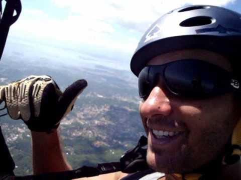
Sampaio Correia, located in the state of Rio de Janeiro, Brazil, is a highly popular paragliding site known for its excellent cross-country (XC) potential. The main launch direction is northwest (NW), and the site offers a variety of launch points ranging from 350 to 700 meters in altitude, providing stunning views of the sea, lakes, and jungle. The site is approximately 70 km from Rio de Janeiro. To get there, take the Amaral Peixoto road towards Sampaio Correia. After descending the mountain, turn left onto a dirt road marked with a "Vôo Livre" sign. The dirt road is about 4.5 km long and is accessible by most vehicles. The north ramp is an additional 7 km, with the last 500 meters requiring a short walk. 
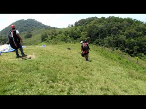
The north ramp has ample space for setting up and launching multiple paragliders, with a gentle slope for takeoff. There are also ramps oriented to the northeast (NE) and east (L), suitable for both hang gliders and paragliders. The predominant wind direction in the region is from the north. The official landing zone is at "Feno," located on a farm below the south (S) and southeast (SE) ramps, near a gas station. To reach this landing zone, pilots must ensure they have enough altitude to cross the ridge. In less favorable conditions, an alternative landing zone is available at Tingui, which is not visible from the ramp and requires sufficient altitude to spot. The best time to fly is in September, although the site offers flying opportunities year-round. The local paragliding club, AVLSC, provides more information and support for pilots. Pros of flying at Sampaio Correia include beautiful scenery, the potential for long-distance flights, and easy retrieval along the highway. However, landing below the north and northeast ramps can require hours of walking, and if pilots launch and stay low, they may quickly lose altitude due to venturi effects. For accommodations and dining, there are excellent options near the ramp, such as the QG do Voo Livre do Werneck. Visit [QG do Voo Livre](http://www.qgdovoolivre.com.br) for more details. For more information, you can also visit: - [Ondas do Vento](http://www.ondasdovento.com.br/voolivre/rampa-norte-sampaio-correia/) - [Guia 4 Ventos](http://www.guia4ventos.com.br/rampas-do-brasil/34-rampas-de-voo-livre-rj/185-sampaio-correia-rampa-de-sampaio-correia-rj-) Contact numbers for local support and 4x4 truck retrieval services are available: - Nextel: (22) 7835-7503 ID - 87*11961 Record flights include a 165 km paragliding flight to Bananal and a 91 km hang gliding flight to Adrianópolis. For more details, visit [Paragliding365](http://www.paragliding365.com).
Popularity: 39 Views

Rio Bonito-RJ

Paragliding map of
Optimal Wind Direction
SE SSE S SSW SW WSW

Optimal Speed (kmh)

Location: Rio Bonito, Rio de Janeiro, Brazil Altitude: 600 meters Vertical Drop: 570 meters Wind Directions: South (S), Southeast (SE), Southwest (SW) Coordinates: 22° 41' 15.536"S, 42° 38' 9.262"W Access: Located 60 km from Rio de Janeiro and 40 km from Niterói. Enter the city of Rio Bonito and follow the signs for "Vôo Livre". The site is 5 km from the city center, accessible via a reasonable dirt road suitable for any car. Takeoff: Two concrete ramps suitable for both hang gliders and paragliders, facing West (W) and Southwest (SW). Landing: Multiple landing options below the takeoff area. Best Season: From August to November. Responsible Club: AVLRJ - Associação de Vôo Livre do Rio de Janeiro. Tel.: (21) 3322-0266. Pros: Good thermals and cross-country (XC) potential. Excellent option for SW flights near Rio de Janeiro. Cons: Concrete takeoff is good for hang gliders but a bit short for paragliders. General Information: Limited hotel infrastructure in Rio Bonito. Local Record: Paragliding record of 61 km, from Lavras ramp to Piratininga (Niterói). For more details, visit: - [Guia 4 Ventos](http://www.guia4ventos.com.br/rampas-do-brasil/34-rampas-de-voo-livre-rj/186-rio-bonito-rampa-de-rio-bonito-rj-) - [YouTube Video](
Click to watch video
Youtube Video Thumbnail
) - [Paragliding365](http://www.paragliding365.com)
Popularity: 39 Views

Sampaio Correia East Ramp

Paragliding map of
Optimal Wind Direction
ESE SE SSE

Optimal Speed (kmh)

Located in the state of Rio de Janeiro, Brazil, this paragliding site offers an elevation range between 570 and 630 meters. It is a popular spot for cross-country (XC) flights, with good conditions for extended journeys. The site is regularly used by paragliders, making it a reliable choice for enthusiasts. The local distance record for this site is an impressive 175.1 km, showcasing its potential for long-distance flights. For more detailed information, you can visit the following link: [More Information](https://example.com).
Popularity: 35 Views

Sampaio Correia South

Paragliding map of
Optimal Wind Direction
SE SSE S SSW SW WSW

Optimal Speed (kmh)

Located in the Rio de Janeiro region of Brazil, this paragliding site offers a takeoff altitude of 478 meters. It is frequently used by paragliders and is known for its excellent soaring conditions. Cross-country flights are also possible from this location. The local distance record is 67.9 km. For more information, you can visit the Associação de Voo Livre de São Conrado's website at [http://www.avlsc.com.br](http://www.avlsc.com.br). Additionally, you can watch a video of the site on YouTube: [Watch Video](
Click to watch video
Youtube Video Thumbnail
).
Popularity: 34 Views

Sampaio Correia Rampa Norte

Paragliding map of
Optimal Wind Direction
N NNE NE NW NNW

Optimal Speed (kmh)

Location: Sampaio Correia, RJ, Brazil Altitude: 570 meters (1869.6 feet) Vertical Drop: 470 meters (1541.6 feet) Wind Direction: S, SE, N Access: Take the Amaral Peixoto road towards Sampaio Correia, approximately 70 km from Rio de Janeiro. After descending the mountain, near Sampaio Correia, turn left onto a dirt road (look for the "Vôo Livre" sign). The dirt road is 4.5 km long and accessible to any car. For the north ramp, it's an additional 7 km drive, with the last 500 meters requiring a walk. Alternatively, after descending the mountain, pass the ramp entrance and continue for 500 meters to the Vôo Livre Gas Station, where you can get information about the safest landing spots. You can also call the gas station at (22 – 2654.7001) to check wind conditions before heading out. Take-off: There are two ramps for S and SE winds. The first ramp (Pepê) is slightly over 300 meters, and the second ramp (Rampa Dois) is slightly over 400 meters and closer to the highest point of the flight, which is over 500 meters. The SW flight, when moderate, is very smooth and one of the best. The N ramp is wide and natural but has a small slope angle. Landing: The official landing site is on a farm directly below the ramps. For the N take-off, ensure you have enough altitude to reach the landing site on the S side. The "merreca" (low altitude) landing from the N ramp is towards the East. The landing site is not visible from the ramp, so it's advisable to check it before taking off. Safe landing is always possible, but it may require a long walk. Best Season: All year round, with the best conditions in September. Official Club: [AVL Sampaio Correia](http://www.avlsc.com.br/) Advantages: Beautiful scenery, possibilities for long-distance flights, and easy pilot pick-up along the highway. Disadvantages: Very popular spot with many visitors, especially from the State of Rio de Janeiro. The road has been leveled and cleaned, making it accessible for any car. General Info: At the base of the ramp, there are excellent lodging and dining options such as Pousada Roncador – Restaurante e Bar, known as Casa Roxa among pilots. Visit [Pousada Roncador](http://www.pousadaserradoroncador.com.br) for more information. There is also an unofficial landing area with a windsock in front of Pousada Roncador. For contacts and reservations, call 21 2224.4582 / 2224.9138 or email adegaflordecoimbra@oi.com.br. Records: Paraglider: Ceará, 46 km, flying to Niterói. Hang Glider: Geraldo Nobre and Carlinhos, flying to Adrianópolis, 91 km. For more information, watch this [YouTube video](
Click to watch video
Youtube Video Thumbnail
) and visit [Guia 4 Ventos](http://www.guia4ventos.com.br/rampas-do-brasil/34-rampas-de-voo-livre-rj/185-sampaio-correia-rampa-de-sampaio-correia-rj).
Popularity: 34 Views

Lavras

Paragliding map of
Optimal Wind Direction
ESE SE SSE

Optimal Speed (kmh)

This site, located at an elevation of 602 meters, is rarely used and typically suitable for small to medium flights. It is important not to confuse this location with Lavras-MG. The site is in Brazil and has a recorded flight distance of 11.1 km.
Popularity: 34 Views

rampa norte Marica

Paragliding map of
Optimal Wind Direction
N NNE NNW

Optimal Speed (kmh)

This paragliding site in the RJ region of Brazil has a takeoff altitude of 447 meters. It is rarely used, but small cross-country flights are possible. The local distance record is 19.3 km. For more information, you can visit local paragliding community websites or forums.
Popularity: 30 Views

Via Lagos Boa Esperanca Rio Bonito-RJ

Paragliding map of
Optimal Wind Direction
ENE E ESE WNW NW NNW

Optimal Speed (kmh)

Location: Via Lagos - Rio Bonito, RJ, Brazil Altitude: 346 meters / 1134.88 feet Vertical Drop: 280 meters / 918.4 feet Wind Direction: E|NE|N|NW WayPoint: S 22° 47' 77' W 042° 31' 28' Access: From Rio de Janeiro, head towards Niterói and follow the Niterói-Manilha route. Take the Via Lagos road towards the Região dos Lagos. About 1 km (0.6 miles) before the toll booths, turn left at the Delícias do Rancho restaurant. The ramp is located on the hill just above. The access road is approximately 2 km (1.2 miles) long, with the entrance on the left side of the restaurant. WARNING: Close all the wooden gates on the access road. Take-off: Very easy with N/NW winds; highly technical and unforgiving with E/NE winds. Landing: Several options along the road. Best Season: From May to October. Official Club: Unregistered. Advantages: Great thermals with XC possibilities. Disadvantages: Access is only suitable for 4-wheel drive vehicles. General Info: The ramp is on the property of Mr. Egno, the owner of the restaurant and a significant supporter of free flight in the area. Records: Paraglider: Ceará, 61 km (38 miles) to Piratininga (Niterói). More Information: - [YouTube Video](
Click to watch video
Youtube Video Thumbnail
) - [Dailymotion Video](http://www.dailymotion.com/video/x6o32b_encontro-de-voadores-na-via-lagos-r_sport) - [Guia 4 Ventos](http://www.guia4ventos.com.br/rampas-do-brasil/34-rampas-de-voo-livre-rj/192-rio-bonito-rampa-da-via-lagos-rj-) - [Paragliding365](http://www.paragliding365.com)
Popularity: 29 Views

Closest partner

Find the best sessions
nearby in 1 click.

  • 🤖 Super Forecast algorithm 7d/7
  • 🗺️ Atlas of 32 000 spots
  • Automatic updates (4 times daily)
  • 🛰️ High Resolution Model, Hour by hour
  • 🧭 Radar 50 | 100 | 200 km
  • 💨 16 Weather Models
  • 🔒 Private spot creation
  • ✅ No Ads
  • ✅ Priority Assistance
  • 💪 Support for site development and maintenance 🙏
  • And more...
36$ 9.99$ //year