Guide de voyage Parapente Mont Yamaska

Spots Guru

Trouves les meilleures sessions à proximité en 1 clic.
simple, personnalisable et collaboratif

Parapente Rang du Haut Yamaska 2, QC

Parapente Rang du Haut Yamaska 2, QC

Conditions Optimales

Optimal Wind Direction
NNE NE ENE WNW NW NNW

Optimal Speed (kmh)

Description

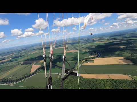
Mount Yamaska offers two takeoff points situated next to each other. One faces North-Northeast (N-NE) and the other North-Northwest (N-NW). This site is frequently used and is known for good thermalling conditions, making it suitable for cross-country (XC) flights. Region: Canada Site record: 67.5 km For a visual experience, check out this video: [Mount Yamaska Paragliding](
Click to watch video
Youtube Video Thumbnail
) Stay updated with the weather at Yamaska: [Yamaska Weather](https://cvly.ca/pages-utilitaires/balise/) If you plan to fly south, be cautious of the Bromont airspace and navigate around it. Mount Yamaska is managed by two clubs, each with its own private takeoff and landing sites, and they organize shuttles up the hill, which takes about 30 minutes. 1) Distance Vol Libre (DVL) - Club & Paragliding School On-Site Office: +1-450-379-5102 2) Club de Vol Libre Yamaska (CVLY) Denis Laferrière, President: +1-514-727-8910 For more information, visit: [Mount Yamaska CVLY](http://www.aqvl.qc.ca/sites/mt_yamaska_cvly/index.shtml) Join the Quebec pilots' community on Facebook: [Quebec Pilots Chat](https://www.facebook.com/groups/1402048566739125/)
Popularité: 177 Vues

Prochaines sessions optimales

(Calculé par l'algorithme de Spots Guru)

    Jeudi 15 Mai

    05:20 20:15
    2 jours de Prévision par semaine sont réservée aux membres.
    Vous êtes un pro ou un club ? Offrez ces prévisions aux utilisateurs et faites la promotion de votre service.

    Mercredi 21 Mai

    05:14 20:22
  • 05h

    NNE 6 | 5km/h
    646 m 100 %
  • 06h

    NE 6 | 7km/h
    659 m 100 %
  • 07h

    NE 6 | 8km/h
    732 m 100 %
  • 08h

    NE 7 | 9km/h
    768 m 100 %
  • 09h

    ENE 7 | 9km/h
    793 m 100 %
  • 10h

    ENE 7 | 7km/h
    817 m 100 %
  • 12h

    ENE 6 | 6km/h
    1049 m 89 %
  • 13h

    ENE 6 | 7km/h
    1269 m 78 %
  • 14h

    NE 6 | 7km/h
    1391 m 67 %
  • 15h

    NE 8 | 9km/h
    1305 m 63 %
  • 16h

    NE 12 | 11km/h
    1110 m 60 %
  • 17h

    NE 13 | 12km/h
    951 m 56 %
  • 18h

    NE 12 | 11km/h
    854 m 51 %
  • 19h

    ENE 11 | 9km/h
    781 m 47 %
  • 20h

    ENE 10 | 7km/h
    707 m 42 %
  • Samedi 24 Mai

    05:11 20:25
  • 14h

    NNW 14 | 21km/h
    488 m 100 %
  • 19h

    NW 13 | 20km/h
    451 m 100 %
  • 20h

    NW 13 | 18km/h
    451 m 100 %
  • Mardi 27 Mai

    05:09 20:28
  • 05h

    NE 10 | 5km/h
    732 m 100 %
  • 06h

    NE 9 | 7km/h
    720 m 100 %
  • 07h

    NE 8 | 10km/h
    683 m 100 %
  • 08h

    NNE 9 | 14km/h
    646 m 100 %
  • 09h

    NNE 11 | 20km/h
    561 m 100 %
  • 19h

    NNW 12 | 20km/h
    402 m 100 %
  • 20h

    NNW 10 | 15km/h
    402 m 100 %

Prévisions Météo Paragliding Rang du Haut Yamaska 2, QC

Sites à proximité

Guide de voyage Parapente Mont Yamaska

Partenaire le plus proche

Parapente Rang du Haut Yamaska 2, QC
Ouest Parapente