/-76.210939265612,4.40442431481716,13/600x300@2x?access_token=pk.eyJ1Ijoic2Vic3dhbiIsImEiOiJjbGZsZ3E1MWowMXRtM3JucGZsbmVsNWlxIn0.NRc39EhAm1tQjmYNgV4zaQ)
At an elevation of 1863 meters and a height difference of approximately 920 meters, this site is extremely popular and can get very crowded, but it is well-organized. A fee is required to fly here. The site offers easy cross-country (XC) flying, with the potential for very good XC flights. Early takeoff is recommended, but be cautious of the El Pacifico wind.
Access to the Aguapanela takeoff is located at La Tulia in Bolivar, Valle del Cauca, just 25 minutes from Roldanillo. You can reach it by taking a bus from the Terminal de Occidente or a paragliding shuttle, meeting at the park in Roldanillo center, followed by a walk.
The Valle del Cauca region extends from Roldanillo 70 km to the north and 170 km to the south, with a valley width ranging from 8 to 40 km. The area is predominantly flat, with 90% of it planted with sugarcane. The tropical humid weather often ensures smooth thermals over a large area, although long dry periods can make flying conditions more challenging. Having some thermal flying experience is important for enjoying flights in Roldanillo. The Pacific wind starts up nearly daily in the afternoon, so starting is possible only up to midday. Even XC pilots who start early move to the east side in the afternoon to fully experience the XC potential of the valley.
Roldanillo, known as Colombia’s flying capital, has hosted numerous international competitions due to its reliable conditions. The tropical climate, influenced by trade winds, is consistent, and the agricultural Valle de Cauca with its unfenced farmland and extensive road network creates a retrieve system that encourages exploration.
The thermals are generally light, except for a rowdy area over the quarry to the south and the Pacific breeze. Early starts are common, and there is not a significant late-night scene. Jeeps (called Willy’s) for the Los Tanques takeoff leave from the Parque Central around 8:45 am, usually from the southeastern corner outside the Juice Palace. These are arranged by locals or long-stay pilots and leave when full. Other launches include La Tulia and Pico, accessible via local public transport and a walk.
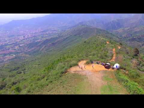
The main takeoff at Los Tanques is 900 meters above the town of Roldanillo in the valley floor and faces east across the wide-open Valle de Cauca. The valley is a political region as well as a geographical feature, located in the west of Colombia, in the middle of a chain of tropical mountains and hills that run the length of the country. One border stretches to the Pacific coast, while jungle-covered mountains rise above 2,000 meters.
Flying starts early, with the thermic breeze hitting launch around 9 am and flights traditionally starting around 11 am. Only a strong Pacific breeze from the west can prevent it. The thermals are often gentle, making the flying almost perfect, although changing weather patterns in recent years have brought stronger conditions.
The valley's topography is ideal for flying cats-cradle tasks with interesting route-finding possibilities. After takeoff, pilots can fly along the western mountains, out into the flats, over to the east hills, and then choose their direction, north or south. Easy logistics make getting back to town with cheap public transport a breeze.
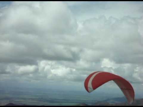
The meteo wind is usually light from either the north or the south. The Pacific sea breeze may produce a strong westerly wind with gusts of 25‐30 km/h later in the day, but this only penetrates 2‐3 km into the valley, allowing pilots full use of the eastern side with little to no effect.
The best season for flying is from December through March and from July to September. Summer (Dec-Mar) is the best, but even in the rainy winter season, 60% of days are flyable. The cloud base ranges from 1,800m to 2,300m, and the moist agricultural climate of the valley reduces the tendency for overdevelopment within the flying area.
There is a dedicated takeoff for hang gliding just 15 minutes from the center of town on the way to La Tulia, at 1,880 meters. The local advice is to "fly anywhere you want to go," with cats-cradle type flying being the norm. Out-and-returns and triangles to land back in Roldanillo are often thwarted by the afternoon Pacifico.
There is an airspace limit of 9,000 feet to the southeast and 10,000 feet to the north. Although often ignored by pilots, it is an issue waiting to happen, so it is best to avoid it. Be careful of climbing out over the back and then not being able to make it back to the landing field. Power lines below launch are clearly visible and easy to avoid. Check foreign office advice before you go, as some border areas of Colombia are no-go zones for travelers.
For weather updates, you can check XCskies.com in conjunction with Meteoblue and Windfinder.
Getting there involves a 60-minute flight from Bogotá to the regional airports of Pereira and Armenia. Roldanillo is a 90-minute taxi ride from both (about €40). Cali International Airport is 90 minutes by taxi or two hours by bus.
If you don’t speak at least a bit of Spanish, it can help to use one of the local guiding services to smooth the way. Two recommended ones are Cloudbase Colombia and Air Nomads.
Warning: The launches in Roldanillo are all lee-side mountain launches and depend on convection to generate upslope thermal breezes for safe launching. A west wind or north wind can create turbulent conditions in front of the launch at Las Tanques. There have been lethal accidents involving very good pilots. If the wind from the back is too strong, it is better not to fly, even if the thermals generate conditions to start at takeoff.
Roldanillo is the best place for competition flying and big triangles, but it comes with challenges. Two sets of high-voltage power lines run along the entire mountain range. There is no official landing field, and the east-facing slopes produce early thermals but also powerful turbulences and lee-sides, making the flying significantly more risky and demanding. The incoming sea breeze from the Pacific Ocean makes launching impossible by early afternoon and turns the ridge into a massive lee-side later on. If you land out early, there is no chance for a second try, and your flying day is over.
For more information on airspace, visit Cloudbase Colombia's airspace page.
Popularity: 158 Views