Paragliding Lijak
Back

Sponsored by

Paragliding Lijak
Les Passagers du Vent

Paragliding Lijak

Region: europe | Country: Slovenia | language: en
Popularity: 39 Views

Jan Feb Sep Oct Nov Dec

Weather Statistics Lijak

History of Maximum Temperatures | | Lijak

JanFebMarAprMayJunJulAugSepOctNovDec
0°c 5 10 15 20 25 30 35 40

History of Daily Maximum Wind Speeds | | Lijak

JanFebMarAprMayJunJulAugSepOctNovDec
0 kmh 5 10 15 20 25 30 35 40

History of Maximum Cloud Ceilings | | Lijak

JanFebMarAprMayJunJulAugSepOctNovDec
0 m 500 1000 1500 2000 2500 3000 3500 4000

History of Daily Rainfall Accumulations | | Lijak

JanFebMarAprMayJunJulAugSepOctNovDec
0 mm 5 10 15 20 25 30 35 40


Where Paragliding | Lijak | Spots map

Find the best sessions
nearby in 1 click.

  • 🤖 Super Forecast algorithm 7d/7
  • 🗺️ Atlas of 32 000 spots
  • Automatic updates (4 times daily)
  • 🛰️ High Resolution Model, Hour by hour
  • 🧭 Radar 50 | 100 | 200 km
  • 💨 16 Weather Models
  • 🔒 Private spot creation
  • ✅ No Ads
  • ✅ Priority Assistance
  • 💪 Support for site development and maintenance 🙏
  • And more...
36$ 9.99$ //year

The best spots of Paragliding | Lijak

Lijak

Paragliding map of
Optimal Wind Direction
SSE S SSW

Optimal Wind Speed (kmh)

Click to watch video
Youtube Video Thumbnail
Click to watch video
Youtube Video Thumbnail
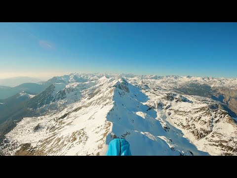
Lijak, located in the Nova Gorica region of Slovenia, is a highly frequented paragliding site known for its excellent soaring conditions and potential for cross-country (XC) flights. The site is flyable more than 300 days a year, with good flying conditions on over 150 days annually, surpassing even popular spots like Tolmin/Stol. Lijak offers a relaxed flying environment similar to the renowned Bassano site in Italy. The ridge allows for wonderful evening soaring, and during the day, usable thermals develop, inviting pilots to embark on XC flights towards the east. The ridge extends for about 30 km, providing ample opportunities for extended flights. On clear days, you can enjoy views stretching all the way to the Mediterranean Sea. The landing area at Lijak is spacious and well-equipped with amenities. There is a kiosk at the landing site, 'Njam Njam,' where you can get burgers and a refreshing drink after your flight. The local club manages the site, and you can pay the start and landing fees there. An information board at the launch site provides essential details, and it's important to adhere to the posted regulations. Access to the launch site is either by car or shuttle heading towards Trnovo. Just before reaching Trnovo, there is a parking area on the right. From there, it's a 10-minute walk downhill to the launch site, which has been well-maintained by the local club. The launch area is suitable for both paragliders and hang gliders, although hang gliders might prefer the ramp located further east along the ridge. This ramp is accessible via Trnovo and a forest road. In addition to flying, Lijak offers other outdoor activities. The surrounding beech forests are perfect for mountain biking, with numerous trails to explore. For accommodation, there is the 'Kamp Lijak' campground located right next to the landing area. When flying at Lijak, please respect the rules at the launch site and in the flying area. For more information, visit  http://www.polet-ng.si/ . For detailed site information, you can also check  http://xcglobe.com/sites#site/23901x5489/ http://paragliding.geopedia.si/en/paragliding_sites.php?id=18). Lijak is a must-visit for any paragliding enthusiast looking for a reliable and enjoyable flying experience in Slovenia.
Popularity: 79 Views

Trstelj Jug

Paragliding map of
Optimal Wind Direction
SE SSE S SSW

Optimal Wind Speed (kmh)

This paragliding site is situated at an elevation of 598 meters. It is not frequently used, making it a quieter option for those looking to avoid crowded spots. The site is suitable for walk&fly activities, meaning you will need to hike to the launch point. Soaring conditions are possible here, providing opportunities for extended flights. For more details, you can visit [this link](http://xcglobe.com/sites#site/23846x5483/).
Popularity: 73 Views

Fobca

Paragliding map of
Optimal Wind Direction
SSW SW WSW

Optimal Wind Speed (kmh)

This paragliding site, situated at an elevation of 715 meters, is infrequently used and typically offers short flights. For more details, you can visit [this link](http://xcglobe.com/sites#site/23930x5478/).
Popularity: 68 Views

M. Sabotino Plave Slapnik

Paragliding map of
Optimal Wind Direction
ESE SE SSE

Optimal Wind Speed (kmh)

At an elevation of 501 meters, this paragliding site is rarely used. It offers limited opportunities for cross-country (XC) flights. For more details, you can visit the provided link: http://xcglobe.com/sites#site/23941x5427/.
Popularity: 66 Views

Korada

Paragliding map of
Optimal Wind Direction
ESE SE SSE

Optimal Wind Speed (kmh)

The takeoff altitude is 749 meters with a height difference of approximately 670 meters. This site is rarely used but offers beautiful scenery and the possibility for cross-country flights. For more information and flight logs, you can visit: http://xcglobe.com/sites#site/23954x5427/ http://www.paraglidingforum.com/leonardo/flight/209729 http://www.paraglidingforum.com/leonardo/flight/163513
Popularity: 65 Views

Brestovica

Paragliding map of
Optimal Wind Direction
SE SSE S SSW SW WSW

Optimal Wind Speed (kmh)

This paragliding site has a height of 254 meters and a horizontal distance of approximately 200 meters. It is considered a medium difficulty site. The site is regularly used and offers good soaring conditions. Some cross-country (XC) flights are possible from this location. For more details, you can visit [this link](http://xcglobe.com/sites#site/23826x5455/).
Popularity: 60 Views

Otlica Kitajska

Paragliding map of
Optimal Wind Direction
SSW SW WSW

Optimal Wind Speed (kmh)

This paragliding site is situated at an elevation of 812 meters. It is not frequently used, but cross-country flights are possible from this location. For more details, you can visit [this link](http://xcglobe.com/sites#site/23883x5560/).
Popularity: 60 Views

Otliški maj

Paragliding map of
Optimal Wind Direction
SSW SW WSW

Optimal Wind Speed (kmh)

This paragliding site is situated at an elevation of 786 meters. It is not frequently used, but cross-country flights are possible from this location. For more details, you can visit [this link](http://xcglobe.com/sites#site/23878x5564/).
Popularity: 55 Views

Čaven Caven

Paragliding map of
Optimal Wind Direction
ENE E ESE SSE S SSW

Optimal Wind Speed (kmh)

The take-off altitude is 1208 meters. This site is regularly used and offers good cross-country (XC) flying opportunities. Top landing is possible here, making it a versatile spot for paragliders. Located in Slovenia, the site has a recorded flight distance of 35.3 km. For more detailed information, you can visit [this link](http://xcglobe.com/sites#site/23883x5544/).
Popularity: 55 Views

Kopica - Kras

Paragliding map of
Optimal Wind Direction
WSW W WNW NW NNW

Optimal Wind Speed (kmh)

This paragliding site has an elevation of 508 meters. It is rarely used and not very relevant for most pilots. The area may be overgrown, which could affect takeoff and landing conditions. For more details, you can visit [this link](https://xcglobe.com/sites#site/23845x5483/).
Popularity: 53 Views

Planina - Ajdovščina

Paragliding map of
Optimal Wind Direction
N NNE NE ENE E

Optimal Wind Speed (kmh)

This paragliding site, with an elevation of 356 meters, is occasionally used. It offers opportunities for soaring, and cross-country (XC) flights are possible. For more details, visit [this link](http://xcglobe.com/sites#site/23842x5567/).
Popularity: 51 Views

Široko Cukla Most na Soci

Paragliding map of
Optimal Wind Direction
N NNE NE

Optimal Wind Speed (kmh)

The take-off site at 754 meters in the Tolmin region of Slovenia is rarely used and typically offers short flights. The site record is 3.7 km, indicating limited flight distance potential. For more details, you can visit [this link](http://xcglobe.com/sites#site/23989x5503/).
Popularity: 51 Views

Rovtarjev Vrh

Paragliding map of
Optimal Wind Direction
N NNE NE

Optimal Wind Speed (kmh)

At an elevation of 1001 meters, this paragliding site is rarely used. It offers opportunities for soaring and the possibility of mini cross-country flights. For more details, visit [this link](http://xcglobe.com/sites#site/23938x5570/).
Popularity: 51 Views

Jelenji vrh

Paragliding map of
Optimal Wind Direction
SSW SW WSW W WNW

Optimal Wind Speed (kmh)

At an elevation of 1129 meters, this paragliding site is infrequently used and typically offers short flights. For more details, you can visit [this link](http://xcglobe.com/sites#site/23935x5550/).
Popularity: 51 Views

Lokve

Paragliding map of
Optimal Wind Direction
SSW SW WSW

Optimal Wind Speed (kmh)

This training hill stands at an elevation of 1040 meters. It is rarely used, making it a quieter spot for those looking to practice without the crowds. For more details, visit [this link](http://xcglobe.com/sites#site/23944x5476/).
Popularity: 51 Views

Razazije

Paragliding map of
Optimal Wind Direction
SSW SW WSW

Optimal Wind Speed (kmh)

This paragliding site is situated at an elevation of 920 meters. It is infrequently used and is known for mostly short flights. For more details, you can visit [this link](http://xcglobe.com/sites#site/23937x5546/).
Popularity: 50 Views

Kucelj

Paragliding map of
Optimal Wind Direction
Any Direction

Optimal Wind Speed (kmh)

At an elevation of 1200 meters, this paragliding site is occasionally used and is suitable for walk & fly activities. Cross-country flights are possible from this location. For more details, you can visit [this link](http://xcglobe.com/sites#site/23883x5530/).
Popularity: 50 Views

Stara Baba

Paragliding map of
Optimal Wind Direction
SSW SW WSW

Optimal Wind Speed (kmh)

This takeoff site is situated at an elevation of 356 meters. It is infrequently used due to its relatively low altitude. However, it can be a viable option for cross-country flights on favorable days, especially when access to higher takeoff points is not possible. For more details, you can visit [this link](http://xcglobe.com/sites#site/23867x5567/).
Popularity: 49 Views

Sabotin

Paragliding map of
Optimal Wind Direction
SSW SW WSW

Optimal Wind Speed (kmh)

This paragliding site, situated at an elevation of 590 meters, is occasionally used and is located on the Italian side of the border. However, it is also considered part of Slovenia since flights frequently head northwards. For more details, you can visit [this link](http://xcglobe.com/sites#site/23901x5489/).
Popularity: 49 Views

-HG Lijak Kopitnik Vitovlje

Paragliding map of
Optimal Wind Direction
SSW SW WSW

Optimal Wind Speed (kmh)

Located at an elevation of 935 meters with a height difference of 872 meters, this launch site is equipped with a ramp specifically designed for hang gliders. It is frequently used and offers excellent cross-country (XC) flying opportunities. The site is known for its potential to achieve significant XC distances, making it a popular choice among experienced pilots. For more detailed information, including photos and additional site specifics, you can visit [Skyfly](http://skyfly.cz/tereny/kopit.htm). Region: Slovenia Site record: 76.4 km For further details, you can also check [XCGlobe](http://xcglobe.com/sites#site/23888x5504/).
Popularity: 48 Views

Govc

Paragliding map of
Optimal Wind Direction
N NNE NE ENE

Optimal Wind Speed (kmh)

This paragliding site has an elevation of 366 meters and is rarely used. It is primarily suitable for soaring. For more details, you can visit [this link](http://xcglobe.com/sites#site/23840x5520/).
Popularity: 47 Views

Kuk gerincen Pod Kukom Kuk nad Paljevim

Paragliding map of
Optimal Wind Direction
SSW SW WSW

Optimal Wind Speed (kmh)

Located at an elevation of 560 meters, this paragliding site in Nova Gorica, Slovenia, offers a moderate experience for enthusiasts. It is regularly used for walk & fly activities and provides good opportunities for soaring. Cross-country (XC) flights are possible from this site, making it a versatile choice for pilots looking to expand their skills. Access to the site requires local knowledge, so it's advisable to ask locals for guidance. Note that there is no official landing zone, so plan your flight accordingly. For more details, you can visit the site information page: [Nova Gorica Paragliding Site](https://xcglobe.com/sites#site/23936x5447/).
Popularity: 47 Views

Slap oddajnik

Paragliding map of
Optimal Wind Direction
SSW SW WSW

Optimal Wind Speed (kmh)

This paragliding site is situated at an elevation of 903 meters. It is rarely used and primarily suitable for soaring. Some cross-country flying is possible, but it is not a popular choice among paragliders. For more details, you can visit [this link](http://xcglobe.com/sites#site/23983x5517/).
Popularity: 44 Views

Otliško Okno

Paragliding map of
Optimal Wind Direction
SSW SW WSW

Optimal Wind Speed (kmh)

This paragliding site has an elevation of 776 meters. It is occasionally used and offers some potential for cross-country (XC) flights. For more details, you can visit the provided link: [xcglobe.com](http://xcglobe.com/sites#site/23877x5565/).
Popularity: 43 Views

Štanjel

Paragliding map of
Optimal Wind Direction
N NNE NE

Optimal Wind Speed (kmh)

This site has an elevation of 296 meters and is infrequently used. It is suitable for short flights and offers some opportunities for soaring. For more details, visit [this link](http://xcglobe.com/sites#site/23828x5539/).
Popularity: 37 Views

Closest partner

Find the best sessions
nearby in 1 click.

  • 🤖 Super Forecast algorithm 7d/7
  • 🗺️ Atlas of 32 000 spots
  • Automatic updates (4 times daily)
  • 🛰️ High Resolution Model, Hour by hour
  • 🧭 Radar 50 | 100 | 200 km
  • 💨 16 Weather Models
  • 🔒 Private spot creation
  • ✅ No Ads
  • ✅ Priority Assistance
  • 💪 Support for site development and maintenance 🙏
  • And more...
36$ 9.99$ //year