Paragliding Bariloche
Back

Sponsored by

Paragliding Bariloche
Alpyr

Paragliding Bariloche

Region: latin america | Country: Argentina | language: en
Popularity: 20 Views

Jan Feb Mar Nov Dec

Weather Statistics Bariloche

History of Maximum Temperatures | | Bariloche

JanFebMarAprMayJunJulAugSepOctNovDec
0°c 5 10 15 20 25 30 35 40

History of Daily Maximum Wind Speeds | | Bariloche

JanFebMarAprMayJunJulAugSepOctNovDec
0 kmh 5 10 15 20 25 30 35 40

History of Maximum Cloud Ceilings | | Bariloche

JanFebMarAprMayJunJulAugSepOctNovDec
0 m 500 1000 1500 2000 2500 3000 3500 4000

History of Daily Rainfall Accumulations | | Bariloche

JanFebMarAprMayJunJulAugSepOctNovDec
0 mm 5 10 15 20 25 30 35 40


Where Paragliding | Bariloche | Spots map

Find the best sessions
nearby in 1 click.

  • 🤖 Super Forecast algorithm 7d/7
  • 🗺️ Atlas of 32 000 spots
  • Automatic updates (4 times daily)
  • 🛰️ High Resolution Model, Hour by hour
  • 🧭 Radar 50 | 100 | 200 km
  • 💨 16 Weather Models
  • 🔒 Private spot creation
  • ✅ No Ads
  • ✅ Priority Assistance
  • 💪 Support for site development and maintenance 🙏
  • And more...
36$ 9.99$ //year

The best spots of Paragliding | Bariloche

Cerro Catedral 2

Paragliding map of
Optimal Wind Direction
N NNE NE ENE E

Optimal Speed (kmh)

Located 20 km from the city of Bariloche, this paragliding site offers a range of takeoff options with altitudes between 1600 and 1965 meters, and a height difference of approximately 1000 meters. The site is known for its panoramic flights and the possibility of cross-country flying, although it is rarely used. Takeoff points include Punta Princesa at 1800 meters above sea level, Piedra del Cóndor at 1750 meters, and Pista Seis at 1600 meters. Landing zones are at the base of the hill for Punta Princesa or Pista Seis (1050 meters above sea level) and the Campo de Vialidad before the hill access for Piedra del Cóndor (950 meters above sea level). The site features both thermal and dynamic flying conditions. Access to the base is possible by vehicle, and you can reach the takeoff points either by using the hill's lift systems or by hiking. A valid flying license is required to fly here. Flights can be made in all directions except south, with the best flying season from October to April, characterized by strong thermal activity. The landing areas are spacious. For more visual information, you can check out these videos: [Video 1](
Click to watch video
Youtube Video Thumbnail
) [Video 2](https://www.youtube.com/watch?app=desktop&v=vGoD92sMPSU) For further inquiries, you can contact Federico de la Mano and Ernesto Gutiérrez.
Popularity: 35 Views

Cerro Catedral Piedra del Cóndor

Paragliding map of
Optimal Wind Direction
N NNE NE NW NNW

Optimal Speed (kmh)

Located in the southwest of Bariloche, Argentina, this paragliding site offers a variety of takeoff options and is regularly used by pilots. The site is known for its potential for cross-country (XC) flights, although thermals and valley breezes can become quite strong in the afternoon. Access to the takeoff points can be achieved either by road or by hiking, as the lifts do not accommodate paragliders. The ski area, which operates in winter, features a gondola that runs seasonally and a chairlift that can take you to the summit. However, be aware that flying above the ski resort and landing within the ski resort area are prohibited. The main takeoff points include: - Punta Princesa at 1800 meters above sea level - Piedra del Cóndor at 1750 meters above sea level - Runway Six at 1600 meters above sea level Landing zones are spacious and include: - Base of the Hill for Punta Princesa or Runway Six (1050 meters above sea level) - Road Field before accessing the hill for Piedra del Cóndor (950 meters above sea level) The site is situated 20 km from the city of Bariloche and can be accessed by vehicle to the base. From there, you can either use the means of elevation or hike up. A license is required to fly at this site, and the best time for flying is from October to April, when thermal activity is strong. Due to controlled airspace, it is mandatory to contact the local airport before flying. For more information and local contacts, you can reach out to: - Parapente en Bariloche: +54 (294) 154413037 - Parapente BRC: +54 (0294) 15 457 2276 - Parapente Cerro Otto: +54 (0294) 15 4303003 For additional details, you can visit [Syride - Piedra Del Condor](https://www.syride.com/it/siti-di-volo/Piedra_Del_Condor). Watch videos of the site: - [Video 1](
Click to watch video
Youtube Video Thumbnail
) - [Video 2](
Click to watch video
Youtube Video Thumbnail
) - [Video 3](https://www.youtube.com/watch?app=desktop&v=M89spZ-s5Go)
Popularity: 31 Views

Bariloche Cerro Otto Malagola

Paragliding map of
Optimal Wind Direction
N WNW NW NNW

Optimal Speed (kmh)

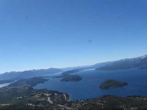
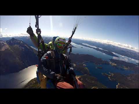
Cerro Otto, located near San Carlos de Bariloche in the Rio Negro province of Argentina, offers a popular paragliding site with a takeoff altitude of 1,380 meters and a height difference of 550 meters. The main takeoff is frequently used, although some pilots prefer Malagola. This site is suitable for thermalling and cross-country (XC) flights, with the best flying season from October to April. Be cautious of strong winds coming over Lake Nahuel Huapi. 
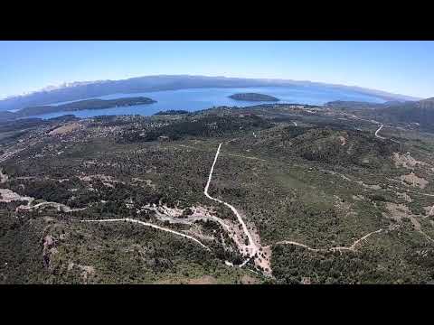
The site is primarily used for local flights. Although there is a cable car to the top, it does not accommodate paragliders, so pilots typically use a vehicle shuttle on flyable days. The launch area is easily accessible, but some alternative takeoff points require more effort to reach. The Patagonian winds significantly influence flying conditions, and the large lake creates its own microclimate. It is essential to consult local pilots for weather forecasts and flying advice. Typical cloudbase ranges from 2,000 to 2,500 meters, offering stunning views of the Argentine plains and the Andes. Cross-country flights can reach altitudes of up to 4,000 meters, traversing a wild landscape with glaciers, mountains, lakes, and rivers. The area is also home to the Andean condor, the largest land bird with a wingspan of up to three meters. The official landing area is small, making it unsuitable for novice pilots. Airspace restrictions apply near the local airport, and strong winds can arrive suddenly. Accommodation options in Bariloche range from five-star hotels to hostels and camping sites. For guidance and courses, contact Federico de la Mano, a local tandem pilot and instructor. More information can be found on the following links: - [Parapente en Bariloche](https://www.facebook.com/parapenteenbariloche/?fref=ts) - [Paragliding Bariloche](https://paraglidingbariloche.com/) - [Bariloche Tourism](http://www.barilocheturismo.gob.ar) For additional details on flying in Bariloche, visit [XC Mag's Guide to Bariloche](https://xcmag.com/travel-guide/guide-to-bariloche-argentina/). If conditions are too windy, consider flying at El Bolson, approximately 120 km south. Always check with local paragliding schools for current landing field information and other nearby takeoff sites.
Popularity: 26 Views

Pichi Leufu

Paragliding map of
Optimal Wind Direction
N NNE NE ENE

Optimal Speed (kmh)

This paragliding site in Argentina is situated at an elevation of 1213 meters with a height difference of 125 meters. It is primarily a walk-and-fly location, meaning you will need to hike to the launch point. The site is rarely used and offers limited soaring opportunities. The longest recorded flight here is 2.2 kilometers. There are no flight logs available for this site.
Popularity: 24 Views

Cresta de Gallo Lago Mascardi

Paragliding map of
Optimal Wind Direction
SSW SW WSW WNW NW NNW

Optimal Speed (kmh)

This paragliding site is situated at an elevation of 1793 meters with a height difference of approximately 900 meters. It is primarily used for hike and fly activities and is rarely frequented. Cross-country flights are possible from this location. The site record for the longest flight is 48.8 km. Unfortunately, there is no additional information available about this site.
Popularity: 24 Views

Refugio Otto Meiling Cerro Tronador

Paragliding map of
Optimal Wind Direction
N NNE NE ENE

Optimal Speed (kmh)

The launch site is situated at an elevation of 1859 meters with a height difference of approximately 980 meters. This location is occasionally used for hike and fly activities and offers a pleasant experience for cross-country (XC) flights. The site has a recorded flight distance of 101.4 km. For more information on paragliding in Argentina, you can visit [Paragliding Argentina](https://www.paraglidingargentina.com).
Popularity: 22 Views

Rio Limay Ruta 40 Anfiteatro

Paragliding map of
Optimal Wind Direction
N NNE ENE E ESE NNW

Optimal Speed (kmh)

This paragliding site, located at an elevation of 804 meters with a height difference of 60 meters, is occasionally used for local soaring. The site offers various takeoff options depending on the wind direction, with a predominant direction of NNE. There is limited information available about this site, and it appears to be less frequently used. The longest recorded flight here is 0.7 km. For more details, you can check the following flight logs: - [Flight Log 1](http://cnd.favl.info/leonardo/flight/1721) - [Flight Log 2](http://cnd.favl.info/leonardo/flight/1720) - [Flight Log 3](http://cnd.favl.info/leonardo/flight/1719)
Popularity: 21 Views

Cerro Ventana

Paragliding map of
Optimal Wind Direction
Any Direction

Optimal Speed (kmh)

Located at an elevation of 1912 meters with a height difference of 1090 meters, this paragliding site is rarely used but offers a unique experience for those who venture here. It is ideal for hike & fly enthusiasts and provides panoramic flights with the possibility of cross-country (XC) flying. The area boasts endless takeoff options, particularly around the NE flank. Region: Bariloche, Argentina. The site record is 55.5 km. For more information, you can visit [Cerro Otto Hike & Fly](http://Cerro OttoHike & Fly).
Popularity: 19 Views

Chacay 1 Rio Carbón

Paragliding map of
Optimal Wind Direction
SSE S SSW SW WSW

Optimal Speed (kmh)

The launch site is situated at an elevation of 1294 meters with a height difference of 555 meters. This location is occasionally used for hike and fly activities and offers opportunities for thermalling. It is also a good spot for cross-country (XC) flying, with a site record of 78.9 km. For a visual experience of the site, you can watch this video: [YouTube Video](
Click to watch video
Youtube Video Thumbnail
). No further information is available about this site.
Popularity: 18 Views

Valle Encantado Neuquèn

Paragliding map of
Optimal Wind Direction
N NNE NE NW NNW

Optimal Speed (kmh)

This paragliding site is situated at an elevation of 1390 meters with a height difference of approximately 660 meters. It is primarily used for hike and fly activities and is rarely frequented by pilots. There is only one small cross-country flight log available for this location. No additional information is available at this time.
Popularity: 17 Views

Chacay 2 Rio Carbón

Paragliding map of
Optimal Wind Direction
NE ENE E ESE SE

Optimal Speed (kmh)

This paragliding site has a takeoff altitude of 1089 meters and a height difference of approximately 320 meters. It is primarily used for hike and fly activities. There is one cross-country flight log available for this location. For more details, you can check the flight log here: [Flight Log](https://www.paraglidingforum.com/leonardo/flight/2164300).
Popularity: 17 Views

Bariloche C Otto alternative

Paragliding map of
Optimal Wind Direction
N NNE NW NNW

Optimal Speed (kmh)

Elevation: 1402 meters, Height Difference: 575 meters This site is accessible by car to the top station, followed by a walk to the launch point. It is rarely used and considered less relevant for paragliding, offering short to medium flights. Region: Argentina Nearby Flights: View flights near this point [10] Local Record: 82.0 km For more information, visit: - Flight Site Base: CLUB PARAFLY Contact: Federico de la Mano and Ernesto Gutiérrez Parapente en Bariloche: +54 (294) 154413037 Parapente BRC: +54 (0294) 15 457 2276 Parapente Cerro Otto: +54 (0294) 15 4303003 https://www.facebook.com/groups/ALASparapente/ Thermal and Dynamic Conditions General Information: Located 5 km from the center of Bariloche, the site can be accessed by cable car or by vehicle via a dirt road. A license is required to fly at this site. It is essential to contact local pilots. The best flying season is from October to April. Due to the technical nature of the landing zones within the city, it is recommended that less experienced pilots seek assistance from their instructors or local pilots. If the wind conditions are too strong, consider heading to El Bolson, approximately 120 km south. Avoid landing beside the chairlift—read the signs. There are two permitted landing fields nearby; check with the local paragliding school. Several other mountains with take-off sites are in the area. For more details, visit: http://www.flightlog.org/fl.html?l=1&a=22&country_id=10&start_id=1151 Additional Information from http://www.porlasnubes.com.ar/lugares.html: Cerro Otto San Carlos de Bariloche - Rio Negro - Argentina Take-off: 1400 meters above sea level - 500 meters elevation difference Landing: 900 meters above sea level Thermal and Dynamic Conditions General Information: Located 5 km from the center of Bariloche, accessible by cable car or vehicle via a dirt road. A license is required to fly at this site. The best flying season is from October to April. Due to the technical nature of the landing zones within the city, it is recommended that less experienced pilots seek assistance from their instructors or local pilots. Local Contacts: Luis Rosenkjer Tel. 02944-427558 luisrosenkjer@infovia.com.ar Nearby Sites: Cerro Catedral, Cerro Piltriquitrón, Cerro Bayo
Popularity: 17 Views

Bariloche Cerro Otto

Paragliding map of
Optimal Wind Direction
N NNE NE ENE NNW

Optimal Speed (kmh)

Located at an altitude of 1297 meters with a height difference of 470 meters, this frequently used paragliding site in Patagonia offers excellent thermal and dynamic soaring conditions. It is well-suited for cross-country flights, including FAI triangles. San Carlos de Bariloche, commonly known as Bariloche, is a picturesque town in northern Patagonia, Argentina. With a population of around 100,000, it sits on the edge of Lake Nahuel Huapi and is surrounded by the Andes mountains. The town is a popular tourist destination known for its hospitality, gastronomy, recreational activities, and vibrant nightlife. In winter, it transforms into one of Argentina's major ski resorts, while summer brings hot, dry, and windy weather. The paragliding scene in Bariloche is relatively small, primarily consisting of tandem and local pilots. Due to bureaucratic issues, pilots cannot use the cable car for launching, but a vehicle shuttle is available on flyable days. The main launch site is easily accessible, though some other sites require more effort to reach. Flying conditions are heavily influenced by the Patagonian winds. The large lake creates its own microclimate, making accurate weather forecasts crucial. Local pilots recommend consulting with them before flying. From December to February, thermals are strong, and the typical cloudbase is around 2,500 meters, offering stunning views of the Argentine plains and the Andes. Cross-country flights can reach altitudes of up to 4,000 meters, traversing a wild landscape of glaciers, mountains, lakes, and rivers. The area is also home to the Andean condor, the world's largest land bird, which uses thermals and convergence lines to travel vast distances. The launch and landing areas are not suitable for hang gliders due to their small size. The site is not recommended for novice pilots due to the technical nature of the landings and airspace restrictions near the airport. Strong winds can also arrive suddenly. Accommodation options in Bariloche range from five-star hotels to backpacker hostels and camping sites. For paragliding guides and courses, Federico de la Mano is a well-known local tandem pilot and instructor. You can find him on Facebook by searching for "Parapente en Bariloche." Bariloche has its own airport with direct flights to Buenos Aires. From the airport, you can take a local bus or taxi to the town center. The main flying site, Cerro Otto, is nearby. Long-distance bus travel in Argentina is comfortable, with the journey from Buenos Aires to Bariloche taking approximately 22 hours. For more information, you can visit: - [Parapente en Bariloche on Facebook](https://www.facebook.com/parapenteenbariloche/?fref=ts) - [Bariloche Tourism](http://www.barilocheturismo.gob.ar) - [Paragliding Bariloche](https://paraglidingbariloche.com/) Contact: - Parapente en Bariloche: +54 (294) 154413037 - Parapente BRC: +54 (0294) 15 457 2276 - Parapente Cerro Otto: +54 (0294) 15 4303003 For a visual experience, check out these videos: - [YouTube Video 1](
Click to watch video
Youtube Video Thumbnail
) - [YouTube Video 2](
Click to watch video
Youtube Video Thumbnail
) - [YouTube Video 3](
Click to watch video
Youtube Video Thumbnail
) - [YouTube Video 4](https://www.facebook.com/watch/?v=217284690276742) - [YouTube Video 5](
Click to watch video
Youtube Video Thumbnail
) For a detailed travel guide, visit: - [Guide to Bariloche, Argentina](https://xcmag.com/travel-guide/guide-to-bariloche-argentina/)
Popularity: 17 Views

Que Mates

Paragliding map of
Optimal Wind Direction
NNE NE ENE WNW NW NNW

Optimal Speed (kmh)

This paragliding site is situated at an elevation of 1718 meters with a height difference of approximately 945 meters. It is rarely used and is primarily suitable for hike & fly activities. Cross-country (XC) flights are possible from this location. Unfortunately, there is no additional information available about this site, and no flight logs have been recorded. The site is located in Argentina, but the specific region is not specified. The site record for the longest flight is 27.1 km.
Popularity: 16 Views

Antena san Ramon

Paragliding map of
Optimal Wind Direction
N W WNW NW NNW

Optimal Speed (kmh)

This paragliding site in Argentina has a takeoff height of 1298 meters and a height difference of 300 meters. It is rarely used, primarily for soaring, with some potential for cross-country (XC) flights. The site record is 10.5 km. The takeoff area allows for launches in four different directions, making it versatile depending on wind conditions. For more information on paragliding in Argentina, you might want to check other local paragliding clubs or forums.
Popularity: 15 Views

Submarino

Paragliding map of
Optimal Wind Direction
ESE SE SSE

Optimal Speed (kmh)

This paragliding site in Argentina is situated at an elevation of 1013 meters with a height difference of 200 meters. It is rarely used but offers potential for good cross-country (XC) flights. Unfortunately, there is no further detailed information available about this site, and no flight logs have been recorded. The site record stands at 116.5 km.
Popularity: 15 Views

Refugio Lopez

Paragliding map of
Optimal Wind Direction
NNE NE ENE E

Optimal Speed (kmh)

At an altitude of 1608 meters with a height difference of approximately 900 meters, this paragliding site is suitable for hike & fly enthusiasts. It is rarely used, and some cross-country (XC) flights are possible. For more information, you can visit: [Instagram](https://www.instagram.com/parapentebrc/?next=%2Falmazkhaziev9577%2Ffeed%2F&hl=de&img_index=1) [Parapente BRC](https://parapentebrc.com/#!/-bienvenido/)
Popularity: 14 Views

Goyerbrum Cerro Goye

Paragliding map of
Optimal Wind Direction
N NNE NE

Optimal Speed (kmh)

Located at an altitude of 1625 meters with a height difference of 852 meters, this paragliding site in Argentina is occasionally used for hike and fly activities. While it offers some potential for cross-country (XC) flights, it is not a highly frequented location. The site record stands at 13.6 kilometers. For a visual overview, you can watch a flight from this site on YouTube: [Watch Video](
Click to watch video
Youtube Video Thumbnail
).
Popularity: 14 Views

Catedral Cerro Bellavista

Paragliding map of
Optimal Wind Direction
N NNE NE ENE

Optimal Speed (kmh)

At an elevation of 1764 meters with a height difference of approximately 1000 meters, this site offers a panoramic flight experience with the possibility of cross-country (XC) flying. It is rarely used and is ideal for hike & fly enthusiasts. Before starting your activity each day, it is mandatory to notify the airport. Make sure to contact local pilots for guidance. If there is no snow, taking off from the summit can be challenging due to the rocky terrain. To reach the site, follow the old road to Colonia Suiza and enter 200 meters at the beginning of the trail to the Jacob refuge. There is paid parking available. The hike is well-marked and very steep but does not present any technical difficulties. Recommended landing spots include the lake beach and the river bed, which are some distance from the parking area. For more information, visit: [Syride - Cerro Bellavista](https://www.syride.com/fr/sites/Cerro_Bellavista) [ALAS Parapente Facebook Group](https://www.facebook.com/groups/ALASparapente/)
Popularity: 14 Views

Cerro David

Paragliding map of
Optimal Wind Direction
SSE S SSW SW WSW

Optimal Speed (kmh)

Located in the stunning region of Patagonia, Argentina, this paragliding site offers an elevation of approximately 1577 meters with a height difference of around 400 meters. It's a great spot for hike and fly enthusiasts and is occasionally used by pilots. The site has a notable cross-country (XC) potential, with a site record of 300.6 km. For a visual experience, you can check out these videos: [Watch Video 1](
Click to watch video
Youtube Video Thumbnail
) [Watch Video 2](https://www.youtube.com/watch?app=desktop&v=LePkH4nkJFs)
Popularity: 14 Views

Cerro Fray Elguea

Paragliding map of
Optimal Wind Direction
N NNE NE ENE NNW

Optimal Speed (kmh)

This paragliding site has a takeoff altitude of 1740 meters and a height difference of approximately 900 meters. It is suitable for hike and fly activities and offers the possibility for cross-country (XC) flights. However, it appears to be a lesser-known location with limited flight logs available.
Popularity: 13 Views

Fortín

Paragliding map of
Optimal Wind Direction
SE SSE S SSW SW WSW

Optimal Speed (kmh)

This paragliding site is situated at an elevation of 1220 meters with a height difference of approximately 330 meters. It is rarely used and is known for its Hike&Fly opportunities, with the option to ascend by horse as well. The site is particularly favorable for cross-country flights in a northerly direction. The region is listed as Argentine, but no specific location details are provided. The site record for the longest flight is 139.8 km. For more information on paragliding in Argentina, you might want to explore other resources or local paragliding clubs.
Popularity: 13 Views

Villa Llanquin

Paragliding map of
Optimal Wind Direction
SSE S SSW SW WSW

Optimal Speed (kmh)

The take-off altitude is 1362 meters with a height difference of approximately 160 meters. This location is suitable for walk & fly activities and has been used for a small cross-country flight, as documented in the flight log linked below. For more details, you can check the flight log here: [Flight Log](https://www.paraglidingforum.com/leonardo/flight/2317480)
Popularity: 13 Views

Cerro Lopez top

Paragliding map of
Optimal Wind Direction
NE ENE E ESE SE

Optimal Speed (kmh)

At an elevation of 2054 meters with a height difference of approximately 1200 meters, this paragliding site offers a unique experience. It is primarily suited for hike & fly enthusiasts, providing a challenging yet rewarding ascent before taking off. The site has limited flight logs, indicating it is not frequently used. Soaring conditions can be expected, but detailed information on weather patterns and wind conditions is sparse. For more details, you can check out a flight log from this location on the Paragliding Forum: [Flight Log](https://www.paraglidingforum.com/leonardo/flight/1426005).
Popularity: 9 Views

near Cerro Bernal

Paragliding map of
Optimal Wind Direction
N WNW NW NNW

Optimal Speed (kmh)

This location has an elevation of 1083 meters with a height difference of 50 meters. It is not a popular spot for paragliding, with only one recorded flight log indicating soaring conditions. There is limited information available, suggesting it is not a frequently used site for paragliding activities.
Popularity: 8 Views

Closest partner

Find the best sessions
nearby in 1 click.

  • 🤖 Super Forecast algorithm 7d/7
  • 🗺️ Atlas of 32 000 spots
  • Automatic updates (4 times daily)
  • 🛰️ High Resolution Model, Hour by hour
  • 🧭 Radar 50 | 100 | 200 km
  • 💨 16 Weather Models
  • 🔒 Private spot creation
  • ✅ No Ads
  • ✅ Priority Assistance
  • 💪 Support for site development and maintenance 🙏
  • And more...
36$ 9.99$ //year